IMAGES TAKEN NEAR TO
Branson Street, MANCHESTER, M40 7FJ
Introduction
This page details the photographs taken nearby to Branson Street, M40 7FJ by members of the Geograph project.
The Geograph project started in 2005 with the aim of publishing, organising and preserving representative images for every square kilometre of Great Britain, Ireland and the Isle of Man.

There are currently over 7.5m images from over14,400 individuals and you can help contribute to the project by visiting https://www.geograph.org.uk
Image Map
Images are licensed for reuse under creativecommons.org/licenses/by-sa/2.0
Notes
- Clicking on the map will re-center to the selected point.
- The higher the marker number, the further away the image location is from the centre of the postcode.
Image Listing (198 Images Found)
Images are licensed for reuse under creativecommons.org/licenses/by-sa/2.0
Image
Details
Distance
1
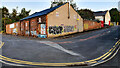
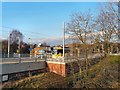
Clyde Street
Building on the corner of Holt Town and Clyde Street.
Image: © Peter McDermott
Taken: 3 Aug 2021
0.01 miles
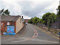
3
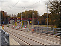
Holt Town
Looking along the line of the new East Manchester extension to the Metrolink, towards the new off-road station at Holt Town.
Image: © David Dixon
Taken: 14 Nov 2012
0.03 miles
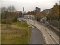
4
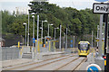
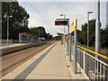
Holt Town tram stop
The tram stop at Holt Town on the metrolink extension to Droylsden (and eventually Ashton under Lyne).
Image: © Gerald England
Taken: 2 Mar 2013
0.03 miles
5
Holt Town
The metrolink tram station from the bus stop on Ashton New Road.
Image: © Gerald England
Taken: 2 Mar 2013
0.03 miles
6
Holt Town Tram Stop
The new Metrolink stop at Holt Town. This off-road station is part of the Metrolink East Manchester Line Extension. This line, which will eventually run to Ashton-Under-Lyne, is scheduled to open “before Christmas 2012” between Manchester Piccadilly and Droylsden
http://www.lrta.org/Manchester/ashton.html LRT Association "Metrolink - Manchester to Droylsden and Ashton-Under-Lyne"
http://www.metrolink.co.uk/futuremetrolink/Pages/east-manchester-line.aspx Transport for Greater Manchester - Metrolink East Manchester Line
Image: © David Dixon
Taken: 14 Nov 2012
0.03 miles
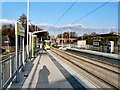
7
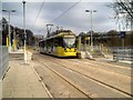
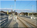
Tram at Holt Town
Metrolink tram number 3045 stops at Holt Town, on a journey from Ashton to Rochdale.
Holt Town is an off–road stop between the road called Holt Town and the River Medlock. Heavy duty concrete piling rigs were used to create concrete retaining walls for the stop. There are two side platforms with steps and track level pedestrian crossings at both ends. An outbound platform ramp and inbound footpath have been provided at the city centre end (http://www.lrta.org/Manchester/ashton.html Light Rail Transit Association).
The Holt Town stop is connected to the City Link footpath, part of the pedestrian route from the City Centre for the 2002 Commonwealth Games.
Image: © David Dixon
Taken: 7 Feb 2015
0.03 miles
8
Holt Town tram stop
Looking towards Droylsden.
Image: © Alan Murray-Rust
Taken: 7 Aug 2013
0.03 miles
9
Holt Town
Metrolink trams stop between New Islington and Etihad Stadium.
Image: © Gerald England
Taken: 12 Jun 2015
0.03 miles
10
Holt Town tram stop
The tram stop at Holt Town on the metrolink extension to Droylsden (and eventually Ashton under Lyne).
Image: © Gerald England
Taken: 2 Mar 2013
0.04 miles