IMAGES TAKEN NEAR TO
Sandal Street, MANCHESTER, M40 7EN
Introduction
This page details the photographs taken nearby to Sandal Street, M40 7EN by members of the Geograph project.
The Geograph project started in 2005 with the aim of publishing, organising and preserving representative images for every square kilometre of Great Britain, Ireland and the Isle of Man.

There are currently over 7.5m images from over14,400 individuals and you can help contribute to the project by visiting https://www.geograph.org.uk
Image Map
Images are licensed for reuse under creativecommons.org/licenses/by-sa/2.0
Notes
- Clicking on the map will re-center to the selected point.
- The higher the marker number, the further away the image location is from the centre of the postcode.
Image Listing (80 Images Found)
Images are licensed for reuse under creativecommons.org/licenses/by-sa/2.0
Image
Details
Distance
1
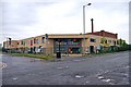
New housing on old streets
New development on Stracey Street, seen from the corner of Sabden Close.
Image: © David Martin
Taken: 20 Nov 2012
0.02 miles
3
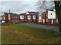
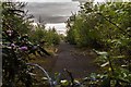
Park View Community School, 31 Varley Street, Miles Platting, Manchester
A large amount of regeneration has gone on in the Miles Platting area, although currently there are still many large vacant sites, where the previous buildings have been demolished. This school, which opened in September 2007 at other premises, relocated to this new building in September 2010. It is on the corner of Varley Street and Holland Street. The school caters for children between the ages of 3 and 11. In the background can be seen part of the huge Victoria Mill, a former cotton mill.
Image: © P L Chadwick
Taken: 7 May 2011
0.11 miles
5
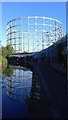
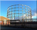
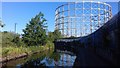
Disused gasometer, Bradford Road, Manchester
Taken from the Ashton Canal, bridge 7 (New Viaduct Street) is just behind the photographer.
Image: © Benjamin Shaw
Taken: 8 Jul 2018
0.14 miles
6
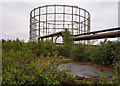
Gasometer
Gasometer in the Bradford Gas Works site.
Image: © Peter McDermott
Taken: 29 Apr 2020
0.14 miles
7
Disused gasometer, Bradford Road, Manchester
Taken from the Ashton Canal, bridge 7 (carrying New Viaduct Street) is just behind the photographer.
Image: © Benjamin Shaw
Taken: 8 Jul 2018
0.14 miles
8
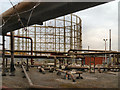
Bradford Gas Works
Part of the Bradford Gas Works, viewed from New Viaduct Street. I don't think the gasholder is in use anymore but the hissing noise from the pipes suggests that they are.
The gasholder is one of two built in the second half of the nineteenth century. Up until the late 1960s, the gasworks together with Bradford Colliery and Bradford Ironworks (Richard Johnson and Nephew) dominated a heavily industrialised landscape which has now almost completely disappeared; giving way to a hypermarket and Sportscity (Velodrome, football stadium etc) with all their associated car parks.
Image: © David Dixon
Taken: 14 Nov 2012
0.14 miles