IMAGES TAKEN NEAR TO
Axbridge Walk, MANCHESTER, M40 7DU
Introduction
This page details the photographs taken nearby to Axbridge Walk, M40 7DU by members of the Geograph project.
The Geograph project started in 2005 with the aim of publishing, organising and preserving representative images for every square kilometre of Great Britain, Ireland and the Isle of Man.

There are currently over 7.5m images from over14,400 individuals and you can help contribute to the project by visiting https://www.geograph.org.uk
Image Map
Images are licensed for reuse under creativecommons.org/licenses/by-sa/2.0
Notes
- Clicking on the map will re-center to the selected point.
- The higher the marker number, the further away the image location is from the centre of the postcode.
Image Listing (174 Images Found)
Images are licensed for reuse under creativecommons.org/licenses/by-sa/2.0
Image
Details
Distance
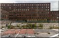
1
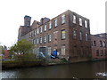
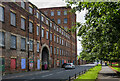
Mill backing onto the Ashton Canal
Image: © Alexander P Kapp
Taken: 25 Oct 2011
0.08 miles
2
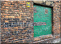
WWII Lancashire: Ghost Signs of the Home Front (3)
-
Brunswick Mill, Bradford Road, Manchester
The sign once read "Nearest Fire Station Pollard Street East". Part of the wording of "Street" and all of "East" in the adjacent green panel has unfortunately been painted out.
Image
Image: © Mike Searle
Taken: 12 Aug 2021
0.08 miles
3
WWII Lancashire: Ghost Signs of the Home Front (4)
-
Brunswick Mill, Bradford Road, Manchester
"Nearest Fire Station Pollard Street East"
Image
Image: © Mike Searle
Taken: 12 Aug 2021
0.08 miles
5
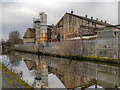
Brunswick Mill
Brunswick Mill on Bradford Street.
Image: © Peter McDermott
Taken: 29 Aug 2015
0.08 miles
7
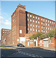
Brunswick Mill, Bradford Road, Manchester
Built c1840. Pevsner describes it as "one of the largest and best preserved of a distinctive type of mid-C19 fireproof mill associated with the designs of William Fairbairn." The lower section facing the street housed the offices. The Ashton Canal runs along the rear. Grade II listed.
In a creative twist, it now has a new life as a recording studio and rehearsal space for local musicians.
Image: © Stephen Richards
Taken: 24 Jul 2011
0.10 miles
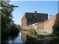
8
Ashton Canal
Looking towards the city centre from the towpath near the Cambrian Street bridge.
Image: © David Dixon
Taken: 21 Nov 2012
0.10 miles
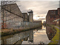
9
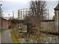
Ashton Canal, Cambrian Street Bridge
The Ashton canal at Ancoats, approaching bridge#6 at Cambrian Street. Beyond the bridge, Image] can be seen. This is one of the two giant gasholders built for the Bradford Gasworks in the second half of the nineteenth century. Up until the late 1960s, the gasworks together with Bradford Colliery and Bradford Ironworks (Richard Johnson and Nephew) dominated a heavily industrialised landscape which has now almost completely disappeared; giving way to a hypermarket and Sportscity (Velodrome, football stadium etc) with all their associated car parks.
Image: © David Dixon
Taken: 21 Nov 2012
0.10 miles
10
Ashton Canal, MG Gas Products
The Ashton Canal at Ancoats, passing the premises of MG Gas Products Ltd (wholesale fuel distributors)
Image: © David Dixon
Taken: 21 Nov 2012
0.10 miles