IMAGES TAKEN NEAR TO
Tewkesbury Road, MANCHESTER, M40 7DH
Introduction
This page details the photographs taken nearby to Tewkesbury Road, M40 7DH by members of the Geograph project.
The Geograph project started in 2005 with the aim of publishing, organising and preserving representative images for every square kilometre of Great Britain, Ireland and the Isle of Man.

There are currently over 7.5m images from over14,400 individuals and you can help contribute to the project by visiting https://www.geograph.org.uk
Image Map
Images are licensed for reuse under creativecommons.org/licenses/by-sa/2.0
Notes
- Clicking on the map will re-center to the selected point.
- The higher the marker number, the further away the image location is from the centre of the postcode.
Image Listing (130 Images Found)
Images are licensed for reuse under creativecommons.org/licenses/by-sa/2.0
Image
Details
Distance
2
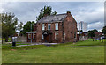
The Navigation
The Navigation public house, seemingly now closed.
Image: © Peter McDermott
Taken: 7 Aug 2016
0.11 miles
4
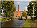
Victoria Mill, Rochdale Canal
A prominent restored mill at Miles Platting.
Image: © michael ely
Taken: 16 May 2014
0.11 miles
5
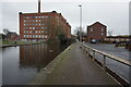
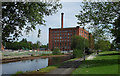
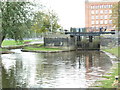
Rochdale Canal and Victoria Mill
A view along the towpath of the Rochdale Canal from lock#80 (Coalpit Lower) towards lock#79 and the impressive Victoria Mill.
Victoria Mill is Miles Platting’s most prominent building. A huge former textile mill which looms over the Rochdale Canal. The six-storey building is composed of two symmetrical mill blocks separated by an engine house. Its distinctive chimney rises within a stair tower and at roof level there is a gallery of windows.
The mill was built in two phases in 1869 and 1873 to a design by the famous Bolton architect George Woodhouse. The mill was built for William Holland who moved his textile business to Miles Platting from his Adelphi Mill in Salford.
The Victoria Mill continued to operate until the 1960s but once it closed it fell into an almost derelict condition until it was restored in the 1990s. Today it is home to apartments, an adult learning centre, and NHS offices.
http://manchesterhistory.net/manchester/outside/victoriamill.html Manchester History Net
http://www.manchester2002-uk.com/history/victorian/mills.html Manchester2002
Image: © David Dixon
Taken: 29 Sep 2012
0.11 miles
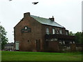
7
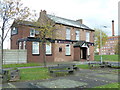
The Navigation, Bourdon Street, Manchester
Image: © Alexander P Kapp
Taken: 25 Oct 2011
0.12 miles
8
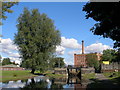
Lock No80 Rochdale Canal, Manchester
Image: © Alexander P Kapp
Taken: 25 Oct 2011
0.12 miles
9
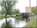
Lock No80 Rochdale Canal, Manchester
Image: © Alexander P Kapp
Taken: 25 Oct 2011
0.12 miles