IMAGES TAKEN NEAR TO
Fourways Walk, MANCHESTER, M40 5RQ
Introduction
This page details the photographs taken nearby to Fourways Walk, M40 5RQ by members of the Geograph project.
The Geograph project started in 2005 with the aim of publishing, organising and preserving representative images for every square kilometre of Great Britain, Ireland and the Isle of Man.

There are currently over 7.5m images from over14,400 individuals and you can help contribute to the project by visiting https://www.geograph.org.uk
Image Map
Images are licensed for reuse under creativecommons.org/licenses/by-sa/2.0
Notes
- Clicking on the map will re-center to the selected point.
- The higher the marker number, the further away the image location is from the centre of the postcode.
Image Listing (17 Images Found)
Images are licensed for reuse under creativecommons.org/licenses/by-sa/2.0
Image
Details
Distance
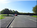
1
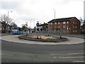
Fourways Roundabout
The block of flats on the right marks the approximate site of the Fourways Cinema, well known (or perhaps notorious) for Saturday children's matinee showings in the 1960s.
Image: © Peter Whatley
Taken: 20 Jan 2010
0.01 miles
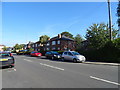
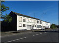
4
Shops on Moston Lane, Moston, M40
Showing position of Postbox No. M40 537.
See pending for postbox.
Image: © JThomas
Taken: 25 Sep 2018
0.11 miles
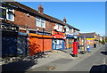
5
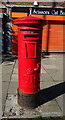
George V postbox on Moston Lane, Moston, M40
Postbox No. M40 537.
See Image] for context.
Image: © JThomas
Taken: 25 Sep 2018
0.11 miles
10
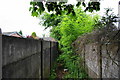
An overgrown footpath
This links Moston Lane with the top end of Boggart Hole Clough. Overgrown in places, it also has rubbish dumped in it further on.
Image: © Bill Boaden
Taken: 7 Jun 2010
0.22 miles