IMAGES TAKEN NEAR TO
Beckford Street, MANCHESTER, M40 5AJ
Introduction
This page details the photographs taken nearby to Beckford Street, M40 5AJ by members of the Geograph project.
The Geograph project started in 2005 with the aim of publishing, organising and preserving representative images for every square kilometre of Great Britain, Ireland and the Isle of Man.

There are currently over 7.5m images from over14,400 individuals and you can help contribute to the project by visiting https://www.geograph.org.uk
Image Map
Images are licensed for reuse under creativecommons.org/licenses/by-sa/2.0
Notes
- Clicking on the map will re-center to the selected point.
- The higher the marker number, the further away the image location is from the centre of the postcode.
Image Listing (35 Images Found)
Images are licensed for reuse under creativecommons.org/licenses/by-sa/2.0
Image
Details
Distance
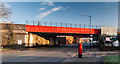
1

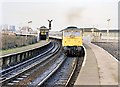
Railway bridge over Oldham Road (A62)
Looking north east.
Image: © JThomas
Taken: 25 Sep 2018
0.06 miles
3
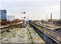
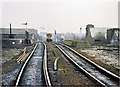
Brewery Sidings junction, Miles Platting 1989
Looking NE from Miles Platting station, the signalbox at Brewery Sidings is in the middle distance, with Wilsons brewery's 1970s buildings on the left. In 2008, nothing recognisable is left, the whole area having become part of Manchester's urban regeneration zone, the station closed and the tracks realigned and resignalled.
Image: © Peter Whatley
Taken: 14 Jan 1989
0.08 miles
4
Oldham Road
Railway bridge crossing Oldham Road.
Image: © Peter McDermott
Taken: 27 Dec 2014
0.09 miles
5
Oldham Road at Queens Road junction, Miles Platting
Image: © Peter Whatley
Taken: 26 Jan 2013
0.11 miles
6
Oldham Road railway bridge 1989
A notorious hump in the line from Miles Platting to Ashton caused by the need to provide clearance for double-deck buses (trams, originally!). Philips Park No.1 signalbox is visible in the distance.
Image: © Peter Whatley
Taken: 11 Feb 1989
0.11 miles
7
Miles Platting Station
The station area as seen in early 1989. The former Area Manager's offices and all station buildings had been demolished by this time (see here for photo of the main station building http://www.geograph.org.uk/photo/1009589). Tickets had to be purchased on the train, though passengers boarding or alighting were a distinct rarity. In the left distance, the dome belongs to a former cinema on Oldham Road, by 1989 in use as a bingo hall.
Image: © Peter Whatley
Taken: 11 Jan 1989
0.15 miles
8
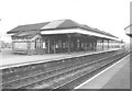
Miles Platting station
Miles Platting was once an important station at the junction of the Oldham (foreground) and Ashton routes. Between the two routes stood this large station building, plus an even larger office for the Area Manager, responsible for the extensive marshalling yards at Miles Platting and slightly further north at Newton Heath and Moston. All traces of the station have now been eradicated.
Image: © Peter Whatley
Taken: Unknown
0.15 miles
9
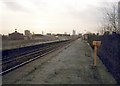
Miles Platting station (Ashton platforms) 1989
The very tight curve of the branch line to Ashton diverging from the original Manchester-Leeds railway line is readily apparent, as are the long sloping access ramps to each of the platforms. Railway operators may notice that the signalman at Miles Platting Junction has replaced his signals to danger remarkably quickly.
Image: © Peter Whatley
Taken: 11 Feb 1989
0.17 miles
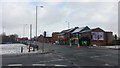
10
Pub and flats
City scene near Newton Heath, Manchester.
Image: © philandju
Taken: 4 Aug 2017
0.17 miles