IMAGES TAKEN NEAR TO
Northampton Road, MANCHESTER, M40 5AG
Introduction
This page details the photographs taken nearby to Northampton Road, M40 5AG by members of the Geograph project.
The Geograph project started in 2005 with the aim of publishing, organising and preserving representative images for every square kilometre of Great Britain, Ireland and the Isle of Man.

There are currently over 7.5m images from over14,400 individuals and you can help contribute to the project by visiting https://www.geograph.org.uk
Image Map
Images are licensed for reuse under creativecommons.org/licenses/by-sa/2.0
Notes
- Clicking on the map will re-center to the selected point.
- The higher the marker number, the further away the image location is from the centre of the postcode.
Image Listing (48 Images Found)
Images are licensed for reuse under creativecommons.org/licenses/by-sa/2.0
Image
Details
Distance
1
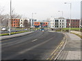
Newton Heath - Thorp Road
The premises in the background are one of several business parks in the vicinity which have replaced failed and often derelict heavy industrial concerns.
Image: © Peter Whatley
Taken: 19 Jan 2011
0.00 miles

3

Central Park
Office buildings on Madison Place, part of the Central Park development.
Image: © Peter McDermott
Taken: 13 Nov 2015
0.02 miles
6
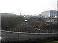
The carriage works' site
Until the 1970s the view here would have been of the former Lancashire & Yorkshire Railway's carriage works, by then in use for a decade as a plant for building concrete construction components for railway use. The works, its associated sidings and most traces of heavy industry are now history, replaced by business parks such as Central Park, visible in the distance, or wasteland.
Image: © Peter Whatley
Taken: 19 Jan 2011
0.14 miles
7

Greater Manchester Police
GMP headquarters building.
Image: © Peter McDermott
Taken: 3 Aug 2013
0.14 miles
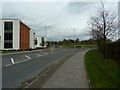
8
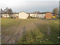
Houses off Thorp Road
A large estate, situated on the former Lancashire & Yorkshire railway's Lightbowne carriage sidings.
Image: © Peter Whatley
Taken: 19 Jan 2011
0.14 miles
9
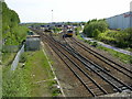
Newton Heath Depot, Newton Heath, Manchester
This depot started life in the 19th century with the arrival of the Lancashire and Yorkshire Railway to the town. The Rochdale canal and the railway provided the impetus to change Newton Heath (the new town on the heath) from an agricultural to industrial community, with soap making, rope making, glass making, match making (as in Lucifers, not dating!!) and varied engineering factories. Newton Heath is also the place where Manchester United Football Club started life in 1879 as Newton Heath F.C., before moving ground and changing name in 1902. SD872007
Image: © Keith Williamson
Taken: 12 May 2005
0.14 miles
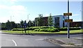
10

Central Park, Greater Manchester Police HQ
GMP’s Divisional HQ on Northampton Road at the Central Park urban renewal development area was opened on 8 February 2012 (http://www.youtube.com/watch?v=_13mL_dSEDY Youtube video of the official opening).
The new complex replaces Bootle Street, Newton Heath and Grey Mare Lane police stations “as they no longer support the needs of a 21st Century police force”.
Image: © David Dixon
Taken: 22 Jul 2012
0.15 miles