IMAGES TAKEN NEAR TO
Dalmahoy Close, MANCHESTER, M40 3WX
Introduction
This page details the photographs taken nearby to Dalmahoy Close, M40 3WX by members of the Geograph project.
The Geograph project started in 2005 with the aim of publishing, organising and preserving representative images for every square kilometre of Great Britain, Ireland and the Isle of Man.

There are currently over 7.5m images from over14,400 individuals and you can help contribute to the project by visiting https://www.geograph.org.uk
Image Map
Images are licensed for reuse under creativecommons.org/licenses/by-sa/2.0
Notes
- Clicking on the map will re-center to the selected point.
- The higher the marker number, the further away the image location is from the centre of the postcode.
Image Listing (9 Images Found)
Images are licensed for reuse under creativecommons.org/licenses/by-sa/2.0
Image
Details
Distance
1

New all weather path near Moston Brook
The path to the north of Moston Brook appears to have been improved where it skirts housing and a new all weather surface laid. Other paths in this valley are impassable such as the one that exits at Williams Road near St Mary's Road.
Image: © Kevin Waterhouse
Taken: 9 Apr 2023
0.02 miles


5
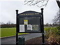
Lower Memorial Park, Failsworth, Sign
Image: © Alexander P Kapp
Taken: 2 Feb 2010
0.16 miles
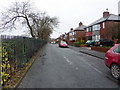
7
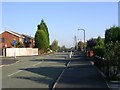
The Fairway
Looking north along The Fairway, New Moston. SD88420141.
Image: © Keith Williamson
Taken: 5 Oct 2005
0.20 miles
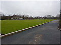
8

Open Land
Recreational open space near Moston Brook. SD88560137.
Image: © Keith Williamson
Taken: 5 Oct 2005
0.22 miles
9
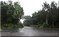
Entrance to the Car Park - Moston Brook
Image: © Anthony Parkes
Taken: 19 Jul 2012
0.22 miles