IMAGES TAKEN NEAR TO
Parkhurst Avenue, MANCHESTER, M40 3QN
Introduction
This page details the photographs taken nearby to Parkhurst Avenue, M40 3QN by members of the Geograph project.
The Geograph project started in 2005 with the aim of publishing, organising and preserving representative images for every square kilometre of Great Britain, Ireland and the Isle of Man.

There are currently over 7.5m images from over14,400 individuals and you can help contribute to the project by visiting https://www.geograph.org.uk
Image Map
Images are licensed for reuse under creativecommons.org/licenses/by-sa/2.0
Notes
- Clicking on the map will re-center to the selected point.
- The higher the marker number, the further away the image location is from the centre of the postcode.
Image Listing (6 Images Found)
Images are licensed for reuse under creativecommons.org/licenses/by-sa/2.0
Image
Details
Distance
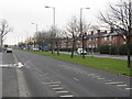
1
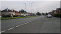
Broadway, New Moston
A view down Broadway (the A663) from the corner of Heppleton Road, in the New Moston area of Manchester - close to the city's border with Chadderton in the Metropolitan Borough of Oldham - in Greater Manchester, England.
Image: © Steven Haslington
Taken: 27 Jun 2011
0.20 miles
2
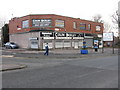
Former chemist's, Broadway
In the 1960s, this building housed a chemist's department where Colin Bickley is now established and - if memory serves - was affiliated to the Co-operative movement.
Image: © Peter Whatley
Taken: 19 Jan 2011
0.22 miles
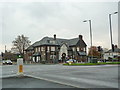
3
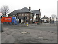
The Broadway Hotel
A 1930s construction, built shortly after Broadway bisected Nuthurst Road, a much older thoroughfare.
Image: © Peter Whatley
Taken: 19 Jan 2011
0.23 miles
5
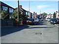
Broadway - looking south from Annesley Road
Image: © Peter Whatley
Taken: 19 Jan 2011
0.23 miles
6
The Broadway, Nuthurst Road, New Moston
Image: © Alexander P Kapp
Taken: 10 Nov 2011
0.24 miles