IMAGES TAKEN NEAR TO
Borland Avenue, MANCHESTER, M40 3LZ
Introduction
This page details the photographs taken nearby to Borland Avenue, M40 3LZ by members of the Geograph project.
The Geograph project started in 2005 with the aim of publishing, organising and preserving representative images for every square kilometre of Great Britain, Ireland and the Isle of Man.

There are currently over 7.5m images from over14,400 individuals and you can help contribute to the project by visiting https://www.geograph.org.uk
Image Map
Images are licensed for reuse under creativecommons.org/licenses/by-sa/2.0
Notes
- Clicking on the map will re-center to the selected point.
- The higher the marker number, the further away the image location is from the centre of the postcode.
Image Listing (19 Images Found)
Images are licensed for reuse under creativecommons.org/licenses/by-sa/2.0
Image
Details
Distance
1
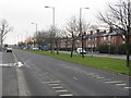
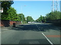
Broadway - looking south from Annesley Road
Image: © Peter Whatley
Taken: 19 Jan 2011
0.05 miles
2
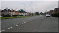
Broadway, New Moston
A view down Broadway (the A663) from the corner of Heppleton Road, in the New Moston area of Manchester - close to the city's border with Chadderton in the Metropolitan Borough of Oldham - in Greater Manchester, England.
Image: © Steven Haslington
Taken: 27 Jun 2011
0.07 miles
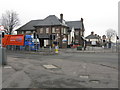
3
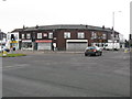
Local shops - Broadway at Nuthurst Road
Following Broadway's construction in the late 1920s, a small row of shops was constructed in the south-west corner of the two roads' intersection. A wider variety of shops was constructed slightly further north where Broadway meets Moston Lane East. (see http://www.geograph.org.uk/photo/2239351, http://www.geograph.org.uk/photo/2239333, http://www.geograph.org.uk/photo/2239311 & http://www.geograph.org.uk/photo/2239369 ).
Image: © Peter Whatley
Taken: 19 Jan 2011
0.09 miles
4
The Broadway, Nuthurst Road, New Moston
Image: © Alexander P Kapp
Taken: 10 Nov 2011
0.11 miles
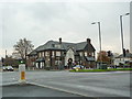
6
The Broadway Hotel
A 1930s construction, built shortly after Broadway bisected Nuthurst Road, a much older thoroughfare.
Image: © Peter Whatley
Taken: 19 Jan 2011
0.13 miles
7
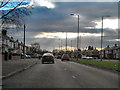
Broadway (A663)
Broadway, just south of Nuthurst Road.
Image: © David Dixon
Taken: 27 Jan 2011
0.13 miles
8
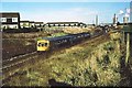
View north from Nuthurst Road bridge 1977
A train from Leeds to Manchester Victoria (despite the destination shown) has recently left Moston station. The line runs in a deep cutting from Hollinwood Avenue to Nuthurst Road passing under a pipe bridge in the middle distance which carries Manchester's drinking water supply from Thirlmere to Audenshaw Reservoir. Prior to 1973, Moston Junction signalbox was located immediately left of the train's front cab. The top right-hand view is dominated by Chadderton electricity generating station and its cooling towers.
Image: © Peter Whatley
Taken: Unknown
0.16 miles
9
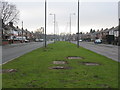
Broadway - looking south from Nuthurst Road
When Broadway was constructed as a new road in the 1920s, the central reservation was intended to accommodate two tram tracks, but none were ever laid.
Image: © Peter Whatley
Taken: 19 Jan 2011
0.19 miles
10
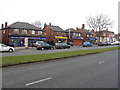
Local shops - Broadway
Some of the shops south of Broadway Baths have mainly sustained the same trades for the past 50 years. Under its 1960s owners, the grocery store was something of an innovator, providing both the first "mini market" (i.e. a diminutive self-service supermarket) in the local area and "Green Shield" trading stamps, an early form of loyalty scheme. The bookmakers seems to have been there for ever.
Image: © Peter Whatley
Taken: 19 Jan 2011
0.21 miles