IMAGES TAKEN NEAR TO
Chauncy Road, MANCHESTER, M40 3GG
Introduction
This page details the photographs taken nearby to Chauncy Road, M40 3GG by members of the Geograph project.
The Geograph project started in 2005 with the aim of publishing, organising and preserving representative images for every square kilometre of Great Britain, Ireland and the Isle of Man.

There are currently over 7.5m images from over14,400 individuals and you can help contribute to the project by visiting https://www.geograph.org.uk
Image Map
Images are licensed for reuse under creativecommons.org/licenses/by-sa/2.0
Notes
- Clicking on the map will re-center to the selected point.
- The higher the marker number, the further away the image location is from the centre of the postcode.
Image Listing (55 Images Found)
Images are licensed for reuse under creativecommons.org/licenses/by-sa/2.0
Image
Details
Distance
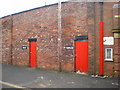
1
Doorway, Springfield Industrial Estate
Image: © Alexander P Kapp
Taken: 27 Jan 2009
0.13 miles
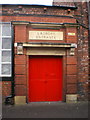
3
Male and female
What were the toilets at Springfield Mill or Laundry
Image: © Alexander P Kapp
Taken: 27 Jan 2009
0.13 miles
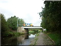
5
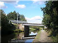
Rochdale Canal, Railway Bridge
Now carries Metrolink
Image: © John Slater
Taken: 22 Sep 2012
0.15 miles
6
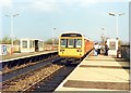
Failsworth station 1989
Archetypal train and unstaffed station from 1980s Greater Manchester PTE.
Image: © Peter Whatley
Taken: 1 Apr 1989
0.15 miles
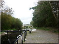
8
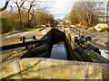
Rochdale Canal; Lock 65
Looking along the lock at Failsworth, from Image
Image: © David Dixon
Taken: 27 Jan 2011
0.16 miles
9
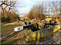
Rochdale Canal; Failsworth Lock.
Lock 65 on the Rochdale Canal at Failsworth.
Image: © David Dixon
Taken: 27 Jan 2011
0.16 miles