IMAGES TAKEN NEAR TO
Douro Street, MANCHESTER, M40 2AU
Introduction
This page details the photographs taken nearby to Douro Street, M40 2AU by members of the Geograph project.
The Geograph project started in 2005 with the aim of publishing, organising and preserving representative images for every square kilometre of Great Britain, Ireland and the Isle of Man.

There are currently over 7.5m images from over14,400 individuals and you can help contribute to the project by visiting https://www.geograph.org.uk
Image Map
Images are licensed for reuse under creativecommons.org/licenses/by-sa/2.0
Notes
- Clicking on the map will re-center to the selected point.
- The higher the marker number, the further away the image location is from the centre of the postcode.
Image Listing (54 Images Found)
Images are licensed for reuse under creativecommons.org/licenses/by-sa/2.0
Image
Details
Distance
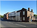
1

The Kippax
Public house at the corner of Bower Street and Grimshaw Lane
Image: © David Dixon
Taken: 2 Mar 2011
0.06 miles
3
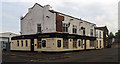
The Kippax
The Kippax public house.
Image: © Peter McDermott
Taken: 22 Aug 2015
0.06 miles
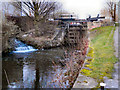
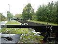
7
Slater's Higher Lock, Rochdale Canal
Lock#75 on the Rochdale Canal.
Image: © David Dixon
Taken: 29 Sep 2012
0.09 miles
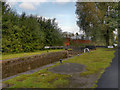
8

Side street off Bower St., between Miles Platting and Newton Heath, Manchester
A typically grim North Country scene. (Evidently some Worker had a posh car - or was it a visiting Doctor; it was not mine).
Image: © Ben Brooksbank
Taken: 18 Apr 1962
0.09 miles
9
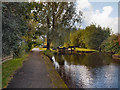
Rochdale Canal, Lock#75 (Slater's Higher)
Image: © David Dixon
Taken: 29 Sep 2012
0.09 miles
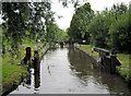
10
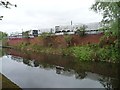
Reflections of stored chemicals, Rochdale Canal
Immediately above Slaters Higher Lock [No 75], on the north-west bank of the canal.
Image: © Christine Johnstone
Taken: 8 May 2014
0.09 miles