IMAGES TAKEN NEAR TO
Flexbury Walk, MANCHESTER, M40 1RL
Introduction
This page details the photographs taken nearby to Flexbury Walk, M40 1RL by members of the Geograph project.
The Geograph project started in 2005 with the aim of publishing, organising and preserving representative images for every square kilometre of Great Britain, Ireland and the Isle of Man.

There are currently over 7.5m images from over14,400 individuals and you can help contribute to the project by visiting https://www.geograph.org.uk
Image Map
Images are licensed for reuse under creativecommons.org/licenses/by-sa/2.0
Notes
- Clicking on the map will re-center to the selected point.
- The higher the marker number, the further away the image location is from the centre of the postcode.
Image Listing (20 Images Found)
Images are licensed for reuse under creativecommons.org/licenses/by-sa/2.0
Image
Details
Distance
1
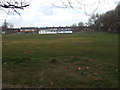
Newton Heath Cricket Club
Looking towards the pavilion at Newton Heath CC. The club run two teams in the Manchester & District Cricket Association.
Image: © BatAndBall
Taken: 21 Mar 2013
0.07 miles
2
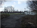
Newton Heath Cricket Club - Ground
Newton Heath CC's Mabel Street ground.
Image: © BatAndBall
Taken: 21 Mar 2013
0.09 miles
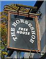
5
The Horseshoe public house
Free house on Droylsden Road.
Image: © JThomas
Taken: 10 Oct 2018
0.14 miles
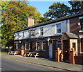
6
The Horseshoe
Public house on Droylsden Road.
Image: © David Dixon
Taken: 9 Apr 2010
0.14 miles
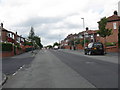
9
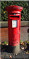
Elizabeth II postbox on Droylsden Road, Manchester M40
Postbox No. M40 111.
Image: © JThomas
Taken: 10 Oct 2018
0.17 miles
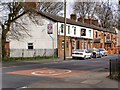
10
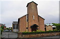
Christ the King church
A Roman Catholic church with quite a presence in the local area; it also has a large club and a primary school.
Image: © Bill Boaden
Taken: 8 Jun 2010
0.18 miles