IMAGES TAKEN NEAR TO
Graver Lane, MANCHESTER, M40 1GL
Introduction
This page details the photographs taken nearby to Graver Lane, M40 1GL by members of the Geograph project.
The Geograph project started in 2005 with the aim of publishing, organising and preserving representative images for every square kilometre of Great Britain, Ireland and the Isle of Man.

There are currently over 7.5m images from over14,400 individuals and you can help contribute to the project by visiting https://www.geograph.org.uk
Image Map
Images are licensed for reuse under creativecommons.org/licenses/by-sa/2.0
Notes
- Clicking on the map will re-center to the selected point.
- The higher the marker number, the further away the image location is from the centre of the postcode.
Image Listing (30 Images Found)
Images are licensed for reuse under creativecommons.org/licenses/by-sa/2.0
Image
Details
Distance
1
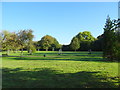
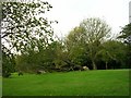
Brookdale Park
Bought by the City Council in 1904 for use as a public park.
Image: © JThomas
Taken: 10 Oct 2018
0.05 miles
4
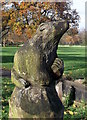
Carved bear, Brookdale Park, Newton Heath
Image: © Linden Milner
Taken: 10 Nov 2013
0.11 miles
6
Storm Damage!
A fallen tree in Brookdale Park, Newton Heath, Manchester. SD89120017.
Image: © Keith Williamson
Taken: 21 Sep 2005
0.16 miles
7
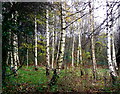
Stand of silver birch trees just outside Brookdale Park
Image: © Linden Milner
Taken: 10 Nov 2013
0.16 miles
8
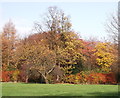
Trees in Brookdale Park, Newton Heath
This is an attractive park with a mixture of open and wooded areas.
Image: © Linden Milner
Taken: 10 Nov 2013
0.16 miles
10
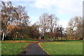
General view of Brookdale Park, Newton Heath
Image: © Linden Milner
Taken: 10 Nov 2013
0.16 miles