IMAGES TAKEN NEAR TO
Millfield Walk, MANCHESTER, M40 0HG
Introduction
This page details the photographs taken nearby to Millfield Walk, M40 0HG by members of the Geograph project.
The Geograph project started in 2005 with the aim of publishing, organising and preserving representative images for every square kilometre of Great Britain, Ireland and the Isle of Man.

There are currently over 7.5m images from over14,400 individuals and you can help contribute to the project by visiting https://www.geograph.org.uk
Image Map
Images are licensed for reuse under creativecommons.org/licenses/by-sa/2.0
Notes
- Clicking on the map will re-center to the selected point.
- The higher the marker number, the further away the image location is from the centre of the postcode.
Image Listing (19 Images Found)
Images are licensed for reuse under creativecommons.org/licenses/by-sa/2.0
Image
Details
Distance
4
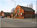
The Methodist Church, Chain Bar
Methodist Church on the corner of Nina Drive with Moston Lane.
Image: © David Dixon
Taken: 9 Apr 2010
0.21 miles
5
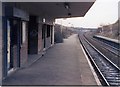
Moston station becoming derelict
By February 1989, the main building's rendering had disappeared and the waiting room had had all breakables removed, effectively leaving a brick-lined space. In terminal decline.
Image: © Peter Whatley
Taken: 11 Feb 1989
0.22 miles

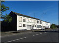
8
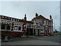
The Gardeners Arms, Lightbowne Road, Moston
Image: © Alexander P Kapp
Taken: 5 Oct 2011
0.23 miles
10
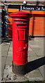
George V postbox on Moston Lane, Moston, M40
Postbox No. M40 537.
See Image] for context.
Image: © JThomas
Taken: 25 Sep 2018
0.23 miles