IMAGES TAKEN NEAR TO
Ottery Walk, MANCHESTER, M40 0GA
Introduction
This page details the photographs taken nearby to Ottery Walk, M40 0GA by members of the Geograph project.
The Geograph project started in 2005 with the aim of publishing, organising and preserving representative images for every square kilometre of Great Britain, Ireland and the Isle of Man.

There are currently over 7.5m images from over14,400 individuals and you can help contribute to the project by visiting https://www.geograph.org.uk
Image Map
Images are licensed for reuse under creativecommons.org/licenses/by-sa/2.0
Notes
- Clicking on the map will re-center to the selected point.
- The higher the marker number, the further away the image location is from the centre of the postcode.
Image Listing (13 Images Found)
Images are licensed for reuse under creativecommons.org/licenses/by-sa/2.0
Image
Details
Distance
1
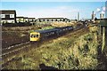
View north from Nuthurst Road bridge 1977
A train from Leeds to Manchester Victoria (despite the destination shown) has recently left Moston station. The line runs in a deep cutting from Hollinwood Avenue to Nuthurst Road passing under a pipe bridge in the middle distance which carries Manchester's drinking water supply from Thirlmere to Audenshaw Reservoir. Prior to 1973, Moston Junction signalbox was located immediately left of the train's front cab. The top right-hand view is dominated by Chadderton electricity generating station and its cooling towers.
Image: © Peter Whatley
Taken: Unknown
0.04 miles
2
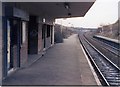
Moston station becoming derelict
By February 1989, the main building's rendering had disappeared and the waiting room had had all breakables removed, effectively leaving a brick-lined space. In terminal decline.
Image: © Peter Whatley
Taken: 11 Feb 1989
0.08 miles
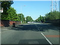
5
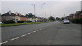
Broadway, New Moston
A view down Broadway (the A663) from the corner of Heppleton Road, in the New Moston area of Manchester - close to the city's border with Chadderton in the Metropolitan Borough of Oldham - in Greater Manchester, England.
Image: © Steven Haslington
Taken: 27 Jun 2011
0.23 miles
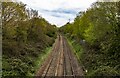
6
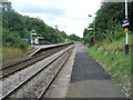
Moston railway station, Greater Manchester, 2009
Opened in 1879 by the Lancashire & Yorkshire Railway on its line from Manchester Victoria to Rochdale. View south towards Manchester in deceptively verdant surroundings, some 8 years before the platform shelters were replaced. See Image for a 2019 view in the opposite direction.
Image: © Nigel Thompson
Taken: 15 Aug 2009
0.24 miles
7
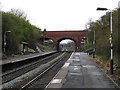
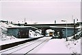
Moston station, looking north
View north from Moston station's Manchester-bound platform, taken around 15.00 on a very wet April 9th, 2008. First bridge is Hollinwood Avenue (A6104); the second is the M60 motorway. Pylon visible through the bridge effectively marks the site of the former Chadderton electricity generating station, now Broadway business park.
Image: © Peter Whatley
Taken: 9 Apr 2008
0.24 miles
8
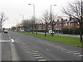
Broadway - looking south from Annesley Road
Image: © Peter Whatley
Taken: 19 Jan 2011
0.24 miles
9
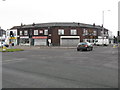
Local shops - Broadway at Nuthurst Road
Following Broadway's construction in the late 1920s, a small row of shops was constructed in the south-west corner of the two roads' intersection. A wider variety of shops was constructed slightly further north where Broadway meets Moston Lane East. (see http://www.geograph.org.uk/photo/2239351, http://www.geograph.org.uk/photo/2239333, http://www.geograph.org.uk/photo/2239311 & http://www.geograph.org.uk/photo/2239369 ).
Image: © Peter Whatley
Taken: 19 Jan 2011
0.24 miles
10
Moston station, looking north in 1979
A Manchester train arrives at Moston in January 1979.
Image: © Peter Whatley
Taken: Unknown
0.24 miles