IMAGES TAKEN NEAR TO
Spa Lane, MANCHESTER, M38 9SJ
Introduction
This page details the photographs taken nearby to Spa Lane, M38 9SJ by members of the Geograph project.
The Geograph project started in 2005 with the aim of publishing, organising and preserving representative images for every square kilometre of Great Britain, Ireland and the Isle of Man.

There are currently over 7.5m images from over14,400 individuals and you can help contribute to the project by visiting https://www.geograph.org.uk
Image Map
Images are licensed for reuse under creativecommons.org/licenses/by-sa/2.0
Notes
- Clicking on the map will re-center to the selected point.
- The higher the marker number, the further away the image location is from the centre of the postcode.
Image Listing (26 Images Found)
Images are licensed for reuse under creativecommons.org/licenses/by-sa/2.0
Image
Details
Distance
1
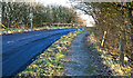
Mown grass strip on the edge of Little Hulton
A buffer between houses to the right and the M61 motorway to the left.
Image: © Bill Boaden
Taken: 7 Sep 2015
0.04 miles
2
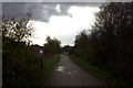
Route 55 path south of the M61 towards Little Hulton
Image: © Robert Eva
Taken: 17 Nov 2017
0.07 miles
3
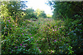
Path to Farnworth
This is the line of the path as marked on the map, but it requires battling through Himalayan balsam. It is much easier to go via the playing fields to the right.
Image: © Bill Boaden
Taken: 7 Sep 2015
0.07 miles
4
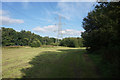
Newcombe Drive (Greenheys), Salford current county/UA top
Highest point looks like Anchor Lane before it leaves the borough of Salford to cross the M61 but man made like the next highest point near junction of Anchor Lane and Newcombe Drive. I go for the patch of accessible grass opposite junction.
Name: Newcombe Drive (Greenheys)
Hill number: 7831
Height: 116m / 380ft
Area: 36: Lancashire, Cheshire & the Southern Pennines
Class: CoU
Grid ref: SD 71965 04912
Summit feature: road junction of Newcombe Drive and Anchor Lane
Drop: 2m
Col: 114m SD713049
Image: © Rude Health
Taken: 3 Mar 2012
0.07 miles
6
Route 55 pedestrian and cycle path towards Little Hulton
Image: © Robert Eva
Taken: 17 Nov 2017
0.08 miles
7
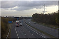
M61 looking east from Anchor Lane bridge
Image: © Robert Eva
Taken: 17 Nov 2017
0.09 miles

9
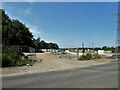
New development
Off Anchor Lane and against the M61 motorway
Image: © Kevin Waterhouse
Taken: 12 Jun 2023
0.11 miles