IMAGES TAKEN NEAR TO
Old Wells Close, MANCHESTER, M38 9PG
Introduction
This page details the photographs taken nearby to Old Wells Close, M38 9PG by members of the Geograph project.
The Geograph project started in 2005 with the aim of publishing, organising and preserving representative images for every square kilometre of Great Britain, Ireland and the Isle of Man.

There are currently over 7.5m images from over14,400 individuals and you can help contribute to the project by visiting https://www.geograph.org.uk
Image Map
Images are licensed for reuse under creativecommons.org/licenses/by-sa/2.0
Notes
- Clicking on the map will re-center to the selected point.
- The higher the marker number, the further away the image location is from the centre of the postcode.
Image Listing (14 Images Found)
Images are licensed for reuse under creativecommons.org/licenses/by-sa/2.0
Image
Details
Distance
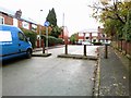
1
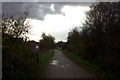
Route 55 junction at Little Hulton
The path on the right goes up to Old Lane
Image: © Robert Eva
Taken: 17 Nov 2017
0.04 miles
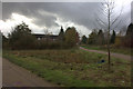
6
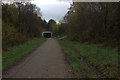
Approaching Cleggs Lane bridge on route 55. Little Hulton
Image: © Robert Eva
Taken: 17 Nov 2017
0.16 miles
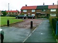
7
Route 55 pedestrian and cycle path towards Little Hulton
Image: © Robert Eva
Taken: 17 Nov 2017
0.17 miles
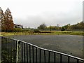
8
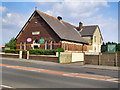
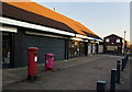
Little Hulton Wesleyan Chapel
The Wesleyan Chapel on Clegg's Lane, Little Hulton.
Image: © David Dixon
Taken: 22 May 2010
0.19 miles
9
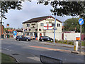
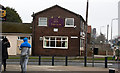
Stumble Inn
Public house, on the corner of Falcon Drive and Clegg's Lane.
Image: © David Dixon
Taken: 22 May 2010
0.22 miles