IMAGES TAKEN NEAR TO
Fern Lea Grove, MANCHESTER, M38 0BY
Introduction
This page details the photographs taken nearby to Fern Lea Grove, M38 0BY by members of the Geograph project.
The Geograph project started in 2005 with the aim of publishing, organising and preserving representative images for every square kilometre of Great Britain, Ireland and the Isle of Man.

There are currently over 7.5m images from over14,400 individuals and you can help contribute to the project by visiting https://www.geograph.org.uk
Image Map
Images are licensed for reuse under creativecommons.org/licenses/by-sa/2.0
Notes
- Clicking on the map will re-center to the selected point.
- The higher the marker number, the further away the image location is from the centre of the postcode.
Image Listing (12 Images Found)
Images are licensed for reuse under creativecommons.org/licenses/by-sa/2.0
Image
Details
Distance
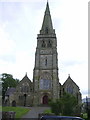
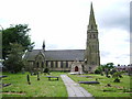
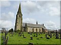
1
Parish Church of St.Paul
Parish church at Peel Park, Little Hulton.
Image: © Roger May
Taken: 2 Dec 2005
0.18 miles
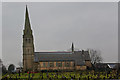
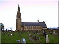
5
Church of St Paul
The parish church for Peel
Image: © Kevin Waterhouse
Taken: 8 Apr 2024
0.23 miles