IMAGES TAKEN NEAR TO
Carding Grove, SALFORD, M3 7NY
Introduction
This page details the photographs taken nearby to Carding Grove, M3 7NY by members of the Geograph project.
The Geograph project started in 2005 with the aim of publishing, organising and preserving representative images for every square kilometre of Great Britain, Ireland and the Isle of Man.

There are currently over 7.5m images from over14,400 individuals and you can help contribute to the project by visiting https://www.geograph.org.uk
Image Map
Images are licensed for reuse under creativecommons.org/licenses/by-sa/2.0
Notes
- Clicking on the map will re-center to the selected point.
- The higher the marker number, the further away the image location is from the centre of the postcode.
Image Listing (60 Images Found)
Images are licensed for reuse under creativecommons.org/licenses/by-sa/2.0
Image
Details
Distance
2
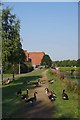
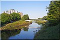
Geese and the Salford Trail
Salford is well stocked with waterbirds especially Canada Geese these were laying claim to the Image
Image: © Glyn Baker
Taken: 31 Aug 2018
0.12 miles
5
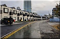
Springfield Lane
New houses on Springfield Lane.
Image: © Peter McDermott
Taken: 21 Oct 2018
0.16 miles
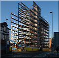
6
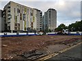
The Copper Works
The Copper Works and 55 Queen Street development site.
Image: © Peter McDermott
Taken: 24 Jul 2020
0.16 miles
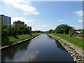
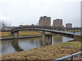
7
Footbridge From the Salford Trail
The Image https://www.ldwa.org.uk/ldp/members/show_path.php?path_name=Salford+Trail on the far bank is a 40 mile circular trail around the city.
Image: © Glyn Baker
Taken: 31 Aug 2018
0.16 miles
8
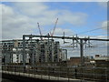
King Street, Greengate
Taken behind 101 Embankment at the new development at Greengate, Salford, Greater Manchester, I am looking across the railway line leading into Victoria Station to the apartment blocks on King Street.
Image: © Carroll Pierce
Taken: 16 Apr 2018
0.16 miles
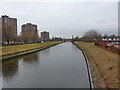
9
Footbridge over the River Irwell
From Cottenham Lane to Philip Street East
Image: © Alexander P Kapp
Taken: 10 Jan 2011
0.17 miles
10
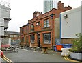
Salford, Eagle Inn
Traditional public house on Collier Street, an island in a redevelopment area. Counter left in lobby, main bar left; second bar right, and snug behind it. Background music, and an entertainment venue in the former house to the left. Good Beer Guide listed; Grade II listed by Historic England: https://historicengland.org.uk/listing/the-list/list-entry/1392691
Image: © Mike Faherty
Taken: 22 Sep 2019
0.17 miles