IMAGES TAKEN NEAR TO
Blackfriars Road, SALFORD, M3 7BU
Introduction
This page details the photographs taken nearby to Blackfriars Road, M3 7BU by members of the Geograph project.
The Geograph project started in 2005 with the aim of publishing, organising and preserving representative images for every square kilometre of Great Britain, Ireland and the Isle of Man.

There are currently over 7.5m images from over14,400 individuals and you can help contribute to the project by visiting https://www.geograph.org.uk
Image Map (Loading...)


Getting Data...Please wait
Leaflet Map data © OpenStreetMap
Images are licensed for reuse under creativecommons.org/licenses/by-sa/2.0
Notes
- Clicking on the map will re-center to the selected point.
- The higher the marker number, the further away the image location is from the centre of the postcode.
Image Listing (468 Images Found)
Images are licensed for reuse under creativecommons.org/licenses/by-sa/2.0
Image
Details
Distance
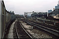
1
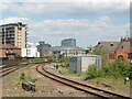
Railway near Chapel Street Bridge
The railway from Salford Central to Manchester Victoria.
Image: © Adrian Taylor
Taken: 12 Jun 2010
0.05 miles
2
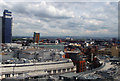
Manc skyline
Taken from the Manchester Wheel
Image: © Allister Combe
Taken: 16 Jun 2008
0.05 miles
3
Cross Street
View looking up Cross Street in Salford.
Image: © Peter McDermott
Taken: 1 Oct 2017
0.06 miles
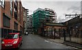
4
Blackfriars Road, Salford
Looking along Blackfriars Road (A6041), towards Blakes' Vauxhall dealership, from Cross Street.
Image: © David Dixon
Taken: Unknown
0.06 miles
5
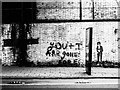
Graffiti and 'Street Art', Blackfriars Rd, Manchester
The figure stencilled on the wall is revered Manchester poet John Cooper Clarke who received an honorary doctorate of Arts from the University of Salford in 2013.
John Cooper Clarke first became famous during the punk rock era of the late 1970s when he was known as a "punk poet". He released several albums in the late 1970s and early 1980s, and continues to perform regularly.
Image: © Matt Harrop
Taken: 5 Dec 2017
0.06 miles
6
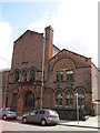
Sacred Trinity Parish School
This building on Blackfriars Road was the former Sacred Trinity Parish School.
Image: © Sue Adair
Taken: 25 Jul 2009
0.06 miles
7
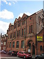
Manchester Tennis & Racquet Courts
Manchester Tennis & Racquets Courts is an uninspiring building on Blackfriars Road, opened in 1880 and designed by architect GT Redmayne. Defying its outer appearance, the interior boasts a number of historical features including a real tennis court and skittle alley.
Image: © Sue Adair
Taken: 25 Jul 2009
0.06 miles
8
Greengate
Buildings of Queen Street in the Greengate area of Salford.
Image: © Peter McDermott
Taken: 18 Oct 2014
0.06 miles
9
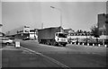
Approaching Manchester Exchange Station
Travelling on a service using the through lines at Manchester Exchange. The station was opened by the London & North Western Railway in June 1884. It was built as a result of congestion at Manchester Victoria station which was owned by the rival Lancashire & Yorkshire Railway where L&NWR trains were often delayed. In the late 1960's British Railways decided that rationalisation was required. Exchange station's passenger services were transferred to Victoria station in May 1969 and the station closed although trains still ran through platforms 3-5. The trainshed, still standing in 1976, was finally demolished in the early 1980's. The tracks through the Exchange were lifted when Victoria station was rebuilt in 1993. The station area is now a car park.
Image: © Martin Addison
Taken: Unknown
0.07 miles
10
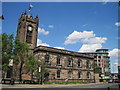
Sacred Trinity Church
Sacred Trinity church was originally built as a chapel-of-ease to serve the growing population of Salford in 1635. It is Salford's oldest church and is a grade II listed building with many original features. Most of the current building dates from 1752 but it was restored in 1877-74 and adapted for more flexible use in the 1980’s. Painted by LS Lowry in 1925 it is one of the only views in his paintings that remains unchanged. William Webb Ellis was
Christened here (famed for inventing the game of Rugby in 1823).
Image: © Sue Adair
Taken: 25 Jul 2009
0.07 miles