IMAGES TAKEN NEAR TO
Blackfriars Street, SALFORD, M3 5JR
Introduction
This page details the photographs taken nearby to Blackfriars Street, M3 5JR by members of the Geograph project.
The Geograph project started in 2005 with the aim of publishing, organising and preserving representative images for every square kilometre of Great Britain, Ireland and the Isle of Man.

There are currently over 7.5m images from over14,400 individuals and you can help contribute to the project by visiting https://www.geograph.org.uk
Image Map (Loading...)


Getting Data...Please wait
Leaflet Map data © OpenStreetMap
Images are licensed for reuse under creativecommons.org/licenses/by-sa/2.0
Notes
- Clicking on the map will re-center to the selected point.
- The higher the marker number, the further away the image location is from the centre of the postcode.
Image Listing (1708 Images Found)
Images are licensed for reuse under creativecommons.org/licenses/by-sa/2.0
Image
Details
Distance
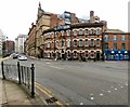
1
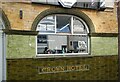
Former Crown Hotel, Blackfriars Street, Salford – detail
Late 19th century decorative tiling on the main front. See https://www.geograph.org.uk/photo/7875650 for location.
Image: © Alan Murray-Rust
Taken: 23 Aug 2024
0.01 miles
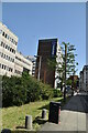
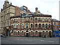
3
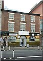
Former Crown Hotel, Blackfriars Street, Salford
Early 19th century public house, the ground floor modernised with decorative moulding and tiling around the end of the century. It had closed as a pub by 2008 – possibly significantly earlier. Listed Grade II in 1980, after many years empty, it became home to a beauty salon around 2014.
Image: © Alan Murray-Rust
Taken: 23 Aug 2024
0.01 miles
7
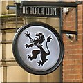
Sign of the Black Lion
The sign for the Black Lion Image
Image: © Gerald England
Taken: 11 Jan 2018
0.03 miles
8
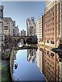
Blackfriars Bridge, River Irwell
The Irwell is the traditional boundary between the cities of Manchester and Salford. The bridge was opened in 1820 to connect Salford with Manchester city centre. It is a Grade II listed structure (English heritage ID:471502 http://www.britishlistedbuildings.co.uk/en-471502-blackfriars-bridge-that-part-in-salford- British Listed Buildings)
Image: © David Dixon
Taken: 11 Mar 2014
0.04 miles
10
Black Lion
There was licensed premises here in 1776 although listed sometimes as the White Lion or the Golden Lion. The present building was built in 1876 for Hardy's Brewery of Hulme. In the 1960s it was a Bass pub and then later an Enterprise Inn. It closed in 2010 but re-opened as a community hub in 2011. http://pubs-of-manchester.blogspot.com/search/label/Black%20Lion%20-%20Chapel%20Street
It now describes itself as a "family run bed and breakfast" and is also part of the franchise of Pieminister. http://www.theblacklionmanchester.co.uk/
Image
Image: © Gerald England
Taken: 11 Jan 2018
0.04 miles