IMAGES TAKEN NEAR TO
New Bailey Street, SALFORD, M3 5FS
Introduction
This page details the photographs taken nearby to New Bailey Street, M3 5FS by members of the Geograph project.
The Geograph project started in 2005 with the aim of publishing, organising and preserving representative images for every square kilometre of Great Britain, Ireland and the Isle of Man.

There are currently over 7.5m images from over14,400 individuals and you can help contribute to the project by visiting https://www.geograph.org.uk
Image Map (Loading...)


Getting Data...Please wait
Leaflet Map data © OpenStreetMap
Images are licensed for reuse under creativecommons.org/licenses/by-sa/2.0
Notes
- Clicking on the map will re-center to the selected point.
- The higher the marker number, the further away the image location is from the centre of the postcode.
Image Listing (615 Images Found)
Images are licensed for reuse under creativecommons.org/licenses/by-sa/2.0
Image
Details
Distance
1
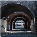
Spaw Street
Spaw Street passing under the railway in Salford.
Image: © Peter McDermott
Taken: 4 Jun 2016
0.02 miles
2
New Bailey Street
Image: © Gerald England
Taken: 2 Sep 2009
0.02 miles
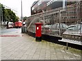
3

Victorian Postbox
On New Bailey Street Image near Salford Central Station.
Image: © Gerald England
Taken: 2 Sep 2009
0.02 miles
4
Salford Central Railway Bridge
As a functional construction, the railway bridge at Salford Central presents a stunning collection of architectural features, from the swags and friezes of the bridge span to the acanthus leaf topped columns to the rear.
Image: © Sue Adair
Taken: 23 Jul 2009
0.02 miles
5
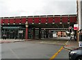
New Bailey Street
Railway bridges over New Bailey Street.
Image: © Gerald England
Taken: 2 Sep 2009
0.02 miles
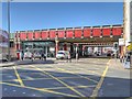
6
New Bailey Street
Railway bridges over New Bailey Street.
Image: © Gerald England
Taken: 2 Sep 2009
0.03 miles
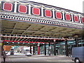
7
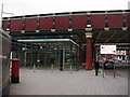
Entrance To Salford Central Station
Part of the new, glass-enclosed frontage at what used to be known simply as Salford station. Redevelopment in the 1990s transformed the immediate area and there is no trace of the earlier station building, documented in 1989 here: http://www.geograph.org.uk/photo/821101.
Image: © Peter Whatley
Taken: 16 Sep 2009
0.03 miles
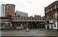
8
Southern Railway Viaduct and Colonnade, Salford
Salford Central Railway Station, opened in 1838 as the terminus and head offices of the Manchester, Bolton and Bury Railway, has three bridges, taking trains to and from Manchester Victoria Station. The three unique bridges that span New Bailey Street, where a single bridge would have sufficed, are an example of the lack of cooperation between railway companies at the time. Influenced by the Greek style, they are each different in design and are each individually Grade II or II* listed buildings.
This is the southernmost bridge (English Heritage ID:471586 http://www.britishlistedbuildings.co.uk/en-471586-southern-railway-viaduct-and-colonnade- ); it was built in 1844 for the Liverpool and Manchester Railway. The entrance to Salford Station can be seen under the bridge, on the left hand side of the road.
A view of the northernmost bridge (English Heritage ID:471585 http://www.britishlistedbuildings.co.uk/en-471585-northern-railway-viaduct- ) also built in 1844 but for the Lancashire and Yorkshire Railway can be seen at Image
The central bridge (English Heritage ID: 471584 http://www.britishlistedbuildings.co.uk/en-471584-central-railway-viaduct- ) is squeezed in between the other two and is almost impossible to photograph from street level (Image] track-level view). It was added in 1865.
Image: © David Dixon
Taken: 11 Mar 2014
0.03 miles
9
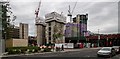
New Bailey
Further development in the New Bailey area of Salford.
Image: © Peter McDermott
Taken: 16 Jun 2019
0.03 miles
10
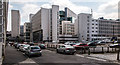
Salford
Office buildings in Salford.
Image: © Peter McDermott
Taken: 4 Jun 2016
0.04 miles