IMAGES TAKEN NEAR TO
Chapel Street, SALFORD, M3 5EQ
Introduction
This page details the photographs taken nearby to Chapel Street, M3 5EQ by members of the Geograph project.
The Geograph project started in 2005 with the aim of publishing, organising and preserving representative images for every square kilometre of Great Britain, Ireland and the Isle of Man.

There are currently over 7.5m images from over14,400 individuals and you can help contribute to the project by visiting https://www.geograph.org.uk
Image Map
Images are licensed for reuse under creativecommons.org/licenses/by-sa/2.0
Notes
- Clicking on the map will re-center to the selected point.
- The higher the marker number, the further away the image location is from the centre of the postcode.
Image Listing (517 Images Found)
Images are licensed for reuse under creativecommons.org/licenses/by-sa/2.0
Image
Details
Distance
1
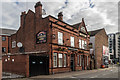
Egerton Arms
The Egerton Arms public house in Salford.
Image: © Peter McDermott
Taken: 3 Jul 2016
0.01 miles
2
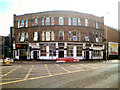
Copperheads Hotel
The Copperheads pub and hotel, which was once the Bulls Head, stands at the corner of New Bailey Street and Chapel Street (A6). The pub was reputedly http://www.visitsalford.info/documents/chapelstreettrail.pdf a favourite haunt of Manchester United star George Best.
Image: © David Dixon
Taken: 24 Jun 2010
0.01 miles
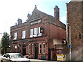
4
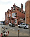
Egerton Arms Hotel
The pub dates from at least 1841 and was once a Joseph Holt pub. http://manchesterhistory.net/manchester/outside/SALFORD/egertonarms.html
Image: © Gerald England
Taken: 5 Mar 2018
0.01 miles
5
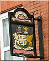
Sign of the Egerton Arms Hotel
The sign of the Egerton Arms Hotel Image] has a coat of arms on it with the motto Virtuti - Non - Armis - Fido which translates as "I Trust to virtue not to arms" which is the motto of Lord Gray De Wilton. In 1784 Sir Thomas Egerton, 7th Baronet, was created Baron Grey de Wilton. The Egertons were the owners of the Tatton Park Estate and his descendent Lord Egerton of Tatton was chairman of the Manchester Ship Canal Company. It was he that turned the first sod in the building of the canal. It may be that the Egerton Arms derives its name from that family. http://manchesterhistory.net/manchester/outside/SALFORD/egertonarms.html
Image: © Gerald England
Taken: 5 Mar 2018
0.01 miles
6
Egerton Arms Hotel
Gore Street, Salford.
Image: © David Dixon
Taken: 24 Jun 2010
0.01 miles
7
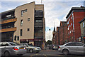
Manchester : Salford - Bloom Street
At the road junction with Chapel Street and New Bailey Street.
Image: © Lewis Clarke
Taken: 11 Oct 2014
0.01 miles
8
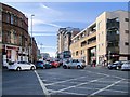
Salford, Chapel Street
The A6 in Salford.
Image: © David Dixon
Taken: 3 Mar 2014
0.02 miles
9
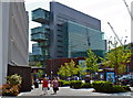
Architectural chest of drawers?
Modern materials and techniques make contemporary buildings less and less conventional in their construction.
Image: © Anthony O'Neil
Taken: 13 May 2016
0.02 miles
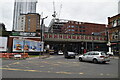
10
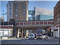
New Bailey Street, Salford Northern Railway Viaduct
Salford Central Railway Station, opened in 1838 as the terminus and head offices of the Manchester, Bolton and Bury Railway, has three bridges, taking trains to and from Manchester Victoria Station. The three unique bridges that span New Bailey Street are an example of the lack of cooperation between railway companies at the time. Influenced by the Greek style, they are each different in design and are each individually Grade II or II* listed buildings.
This is the northernmost bridge (English Heritage ID:471585 http://www.britishlistedbuildings.co.uk/en-471585-northern-railway-viaduct- ) viewed from the opposite side of Chapel Street. It was built in 1844 for the Lancashire and Yorkshire Railway.
A view of the southern bridge (English Heritage ID:471586 http://www.britishlistedbuildings.co.uk/en-471586-southern-railway-viaduct-and-colonnade- ) also built in 1844 but for the Liverpool and Manchester Railway can be seen at Image
The central bridge (English Heritage ID: 471584 http://www.britishlistedbuildings.co.uk/en-471584-central-railway-viaduct- ) is squeezed in between the other two and is almost impossible to photograph from street level. It was added in 1865.
Image: © David Dixon
Taken: 11 Mar 2014
0.02 miles