IMAGES TAKEN NEAR TO
Vale Lane, MANCHESTER, M35 9WG
Introduction
This page details the photographs taken nearby to Vale Lane, M35 9WG by members of the Geograph project.
The Geograph project started in 2005 with the aim of publishing, organising and preserving representative images for every square kilometre of Great Britain, Ireland and the Isle of Man.

There are currently over 7.5m images from over14,400 individuals and you can help contribute to the project by visiting https://www.geograph.org.uk
Image Map
Images are licensed for reuse under creativecommons.org/licenses/by-sa/2.0
Notes
- Clicking on the map will re-center to the selected point.
- The higher the marker number, the further away the image location is from the centre of the postcode.
Image Listing (59 Images Found)
Images are licensed for reuse under creativecommons.org/licenses/by-sa/2.0
Image
Details
Distance
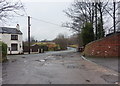
1
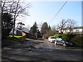
Vale Lane, Bottom of Woodhouses
Vale Lane (off Medlock Road) leading to Medlock Vale Farm (SJ9099).
Image: © John Topping
Taken: 18 Feb 2013
0.04 miles
3
Vale Lane, Failsworth
Road leading to Medlock Vale Farm
Image: © Alexander P Kapp
Taken: 2 Feb 2010
0.05 miles
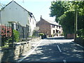
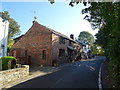
4
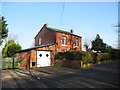
Row of Cottages , Bottom of Woodhouses
Three cottages on Medlock Road, The Stables, Rose Cottage and Fairway Cottage in the hamlet of Bottom of Woodhouses.
Image: © John Topping
Taken: 18 Feb 2013
0.05 miles
5
Junction of Vale Lane and Medlock Road
Image: © Alexander P Kapp
Taken: 2 Feb 2010
0.05 miles
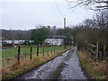
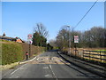
8
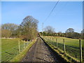
Vale Lane (2)
Vale Lane heading north to Bottom of Woodhouses (SD9000) from Medlock Vale Farm.
Image: © John Topping
Taken: 18 Feb 2013
0.09 miles
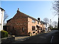
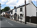
9
400 Medlock Road, Bottom of Woodhouses
Image: © John Topping
Taken: 18 Feb 2013
0.10 miles
10
Entering a 20 mph Zone, Bottom of Woodhouses
Looking east on Medlock Road, from the entrance to Jericho Farm.
Image: © John Topping
Taken: 18 Feb 2013
0.10 miles