IMAGES TAKEN NEAR TO
Simister Road, MANCHESTER, M35 9GD
Introduction
This page details the photographs taken nearby to Simister Road, M35 9GD by members of the Geograph project.
The Geograph project started in 2005 with the aim of publishing, organising and preserving representative images for every square kilometre of Great Britain, Ireland and the Isle of Man.

There are currently over 7.5m images from over14,400 individuals and you can help contribute to the project by visiting https://www.geograph.org.uk
Image Map
Images are licensed for reuse under creativecommons.org/licenses/by-sa/2.0
Notes
- Clicking on the map will re-center to the selected point.
- The higher the marker number, the further away the image location is from the centre of the postcode.
Image Listing (94 Images Found)
Images are licensed for reuse under creativecommons.org/licenses/by-sa/2.0
Image
Details
Distance
1

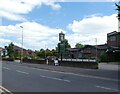
Former Failsworth Driving Test Centre
Located at 2 Partington Street M35 9RD, this driving test centre covers practical driving tests for cars, motorcycles and taxis along nearby roads. It is perhaps rather unfortunate that this DTC doesn't have a more prepossessing appearance with the window coverings being rather prominent to candidates as they arrive there to take their tests. The notice near the entrance refers to DSA (Driving Standards Agency) Safe Driving For Life. Update: this DTC closed on Friday 15th September 2017.
Image: © David Hillas
Taken: 24 Jun 2015
0.09 miles
2
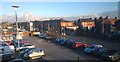
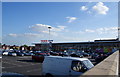
A view towards Ashton Road West, Failsworth
From the first floor of a Tesco supermarket in Failsworth, Greater Manchester, Ashton Road West comes in to view as the perimeter of the store's car park.
Image: © Steven Haslington
Taken: 20 Jan 2014
0.09 miles
3
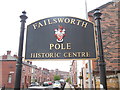
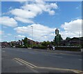
Failsworth Pole Sign
This photo shows the sign at the South end of Main Street M35 9PD near Ashton Road West. It has the coat of arms of the former Failsworth Urban District Council which disappeared on the 1st April 1974 when it was included in the new Metropolitan Borough of Oldham.
Image: © David Hillas
Taken: 24 Jun 2015
0.14 miles
5
Millgate: signage
The sign for Millgate Image
Image: © Gerald England
Taken: 12 Jun 2021
0.15 miles
6
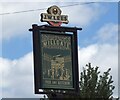
The Millgate
The J W Lees house was built on the site of the Failsworth British Legion Club. It is a traditional family friendly carvery pub.
Image
Image: © Gerald England
Taken: 12 Jun 2021
0.15 miles
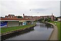
8
Rochdale Canal at Failsworth
Looking south from the towpath, close to the Manchester Road bridge.
Image: © David Dixon
Taken: 27 Jan 2011
0.17 miles
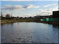
9
Bend in the Rochdale Canal Failsworth
Here the direction of the canal turns from North East to due north
Image: © Glyn Baker
Taken: 24 Sep 2016
0.17 miles
10
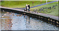
Feeding Time!
Feeding time on the Rochdale Canal in Failsworth.
Image: © Peter McDermott
Taken: 27 Dec 2014
0.17 miles