IMAGES TAKEN NEAR TO
Phoenix Industrial Estate, MANCHESTER, M35 9DS
Introduction
This page details the photographs taken nearby to Phoenix Industrial Estate, M35 9DS by members of the Geograph project.
The Geograph project started in 2005 with the aim of publishing, organising and preserving representative images for every square kilometre of Great Britain, Ireland and the Isle of Man.

There are currently over 7.5m images from over14,400 individuals and you can help contribute to the project by visiting https://www.geograph.org.uk
Image Map
Images are licensed for reuse under creativecommons.org/licenses/by-sa/2.0
Notes
- Clicking on the map will re-center to the selected point.
- The higher the marker number, the further away the image location is from the centre of the postcode.
Image Listing (48 Images Found)
Images are licensed for reuse under creativecommons.org/licenses/by-sa/2.0
Image
Details
Distance
2
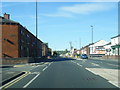
Oldham Road, Failsworth
Oldham Road (A62) between Evening Street and Derby Street, in Failsworth.
Image: © David Dixon
Taken: 27 Jan 2011
0.08 miles
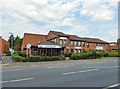
3
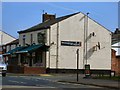
The Sun Inn
On the corner of Oldham Road and Cheetham Street.
Image: © Gerald England
Taken: 13 Sep 2016
0.08 miles
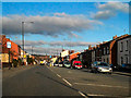
4

A62, Hollinwood
The pedestrian-controlled crossing on Oldham Road (A62), near to Robert Street, between Failsworth and Hollinwood.
Image: © David Dixon
Taken: 27 Jan 2011
0.09 miles
5

Salvation Army Community Church
The Salvation Army Community Church on the corner of Oldham Road and Grafton Street dates from 1995.
Image: © Gerald England
Taken: 13 Sep 2016
0.11 miles
6
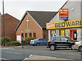
Hope Methodist Church
The present Hope Methodist Church on Oldham Street was built in 1991. It replaces a previous church built in 1866. That was a replacement for an earlier building on the corner of Evening Street.
The United Bedware shop next door would seem to be more ephemeral.
Image: © Gerald England
Taken: 13 Sep 2016
0.12 miles
7
Salvation Army Community Church
The Salvation Army Community Church on the corner of Oldham Road and Grafton Street dates from 1995.
Image: © Gerald England
Taken: 13 Sep 2016
0.13 miles
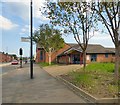
8
Clock House Cafe
The Clock House cafe is run by Age Concern and is alongside the Ena Hughes Resource Centre which includes the Oldham Cancer Support Centre.
Image: © Gerald England
Taken: 13 Sep 2016
0.15 miles
9
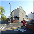
House on Wickentree Lane, Failsworth
Showing position of Postbox No. M35 281.
See Image] for postbox.
Image: © JThomas
Taken: 10 Oct 2018
0.16 miles
10
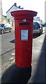
George V postbox on Wickentree Lane, Failsworth
Postbox No. M35 281.
See Image] for context.
Image: © JThomas
Taken: 10 Oct 2018
0.16 miles