IMAGES TAKEN NEAR TO
Wrigley Head, MANCHESTER, M35 9BL
Introduction
This page details the photographs taken nearby to Wrigley Head, M35 9BL by members of the Geograph project.
The Geograph project started in 2005 with the aim of publishing, organising and preserving representative images for every square kilometre of Great Britain, Ireland and the Isle of Man.

There are currently over 7.5m images from over14,400 individuals and you can help contribute to the project by visiting https://www.geograph.org.uk
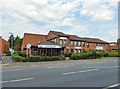
Image Map
Images are licensed for reuse under creativecommons.org/licenses/by-sa/2.0
Notes
- Clicking on the map will re-center to the selected point.
- The higher the marker number, the further away the image location is from the centre of the postcode.
Image Listing (109 Images Found)
Images are licensed for reuse under creativecommons.org/licenses/by-sa/2.0
Image
Details
Distance
1
Clock House Cafe
The Clock House cafe is run by Age Concern and is alongside the Ena Hughes Resource Centre which includes the Oldham Cancer Support Centre.
Image: © Gerald England
Taken: 13 Sep 2016
0.05 miles
2
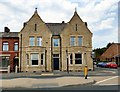
Failsworth Police Station (former)
Failsworth Police Station was opened in 1892 by the Lancashire Constabulary and was originally run by special constables. It was later transferred to Greater Manchester Police and until recently was the home of the Failsworth and Hollinwood Neighbourhood Policing Team.
It was sold at auction for £190,000 in February 2016. It was described as "Two storey (plus basement) end of terrace former police station premises with enclosed and gated rear car park. The property is being sold with a restrictive covenant in place which restricts the property from being used as a HMO in the future."
Image
Image: © Gerald England
Taken: 13 Sep 2016
0.05 miles
3
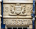
Date stone and coat of arms at Failsworth Police Station
The date 1892 and the coat of arms of the Lancashire Constabulary above the door of the former Failsworth Police Station Image
Image: © Gerald England
Taken: 13 Sep 2016
0.05 miles
4
Salvation Army Community Church
The Salvation Army Community Church on the corner of Oldham Road and Grafton Street dates from 1995.
Image: © Gerald England
Taken: 13 Sep 2016
0.07 miles
5
Salvation Army Community Church
The Salvation Army Community Church on the corner of Oldham Road and Grafton Street dates from 1995.
Image: © Gerald England
Taken: 13 Sep 2016
0.08 miles
6
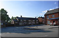
The Pack Horse, Failsworth
There is a surprisingly large number of pubs in the immediate vicinity of Failsworth Pole, but this one is slightly more reclusive. Viewed from the other side of Oldham Road.
Image: © Bill Boaden
Taken: 2 Jun 2010
0.09 miles
7
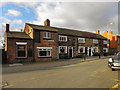
Pack Horse Inn
The Pack Horse Inn, on Wrigley Head, Failsworth.
Image: © David Dixon
Taken: 27 Jan 2011
0.10 miles
9
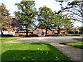
St John's churchyard
The churchyard of St John the Evangelist looking towards the former Gospel Mission Image on Church Street.
Image: © Gerald England
Taken: 13 Sep 2016
0.11 miles
10
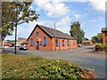
Gospel Mission Hall
The Gospel Mission Hall Image on Church Street dates from 1888 and is now used by St John's as a meeting hall.
Image: © Gerald England
Taken: 13 Sep 2016
0.11 miles