IMAGES TAKEN NEAR TO
Lodge Hall Drive, MANCHESTER, M35 0SY

Introduction

This page details the photographs taken nearby to Lodge Hall Drive, M35 0SY by members of the Geograph project.

The Geograph project started in 2005 with the aim of publishing, organising and preserving representative images for every square kilometre of Great Britain, Ireland and the Isle of Man.

There are currently over 7.5m images from over14,400 individuals and you can help contribute to the project by visiting https://www.geograph.org.uk

Image Map


Images are licensed for reuse under creativecommons.org/licenses/by-sa/2.0
Notes
  • Clicking on the map will re-center to the selected point.
  • The higher the marker number, the further away the image location is from the centre of the postcode.

Image Listing (48 Images Found)

Images are licensed for reuse under creativecommons.org/licenses/by-sa/2.0
  • ...
Image
Details
Distance
1
Lodge Hall
Image: © Peter McDermott Taken: 9 May 2021
0.07 miles
2
Holy Trinity Church, Failsworth, Doorway
Image: © Alexander P Kapp Taken: 27 Jan 2009
0.08 miles
3
Holy Trinity Church, Failsworth
Image: © Alexander P Kapp Taken: 27 Jan 2009
0.09 miles
4
Entrance to Holy Trinity
Holy Trinity, Failsworth Image was founded in the 1870s as a mission church to St John's. It became a parish in its own right in 1907. The current building opened in 1909 and closed in 2007. The architect of the church was Richard Knill Freeman of Bolton http://www.davidfrench.org.uk/knillfreeman/frf/churches/holytrinityfailsworth.html The modern building on the left is the former vicarage now a private house. The current owner allowed me to photograph the building but knew nothing about the church's history.
Image: © Gerald England Taken: 13 Sep 2016
0.10 miles
5
Mill Street bridge
From Mill Lane bridge over what is now the Metrolink tram route to Oldham and Rochdale.
Image: © Gerald England Taken: 13 Sep 2016
0.10 miles
6
Holy Trinity Vicarage
The former vicarage in the grounds of Holy Trinity, Failsworth Image Now a private residence.
Image: © Gerald England Taken: 13 Sep 2016
0.11 miles
7
Signage (ancient and modern)
At the junction of the A62 and the A663 in Failsworth the old style road sign, provided by the former Failsworth Urban District Council, is flanked by contemporary Highways Agency signs adapted for the motorway age.
Image: © Peter Thwaite Taken: 12 Jun 2010
0.11 miles
8
Failsworth TA Centre
Users of the Failsworth TA centre on Oldham Road include: Failsworth Detachment of the Royal Engineers Cadet Force https://armycadets.com/county/greater-manchester-acf/ 317 Failsworth http://www.317atc.com/ Squadron of the Air Training Corps. Skill Force North West http://www.aals.org.uk/aals/provider_detail.php?ref_no=R1475
Image: © Gerald England Taken: 13 Sep 2016
0.11 miles
9
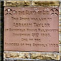
Stone laid by Abraham Taylor
The inscription on this stone at Holy Trinity, Failsworth Image reads: TO THE GLORY OF GOD. THIS STONE WAS LAID BY ABRAHAM TAYLOR OF SANDFIELD HOUSE FAILSWORTH. NOVEMBER 21ST 1908. ONE OF THE FOUNDERS OF THE SCHOOLS 1874.
Image: © Gerald England Taken: 13 Sep 2016
0.11 miles
10
Holy Trinity, Failsworth
Holy Trinity, Failsworth was founded in the 1870s as a mission church to St John's. It became a parish in its own right in 1907. The current building opened in 1909 and closed in 2007. The architect of the church was Richard Knill Freeman of Bolton http://www.davidfrench.org.uk/knillfreeman/frf/churches/holytrinityfailsworth.html
Image: © Gerald England Taken: 13 Sep 2016
0.11 miles
  • ...