IMAGES TAKEN NEAR TO
Lord Lane, MANCHESTER, M35 0PX
Introduction
This page details the photographs taken nearby to Lord Lane, M35 0PX by members of the Geograph project.
The Geograph project started in 2005 with the aim of publishing, organising and preserving representative images for every square kilometre of Great Britain, Ireland and the Isle of Man.

There are currently over 7.5m images from over14,400 individuals and you can help contribute to the project by visiting https://www.geograph.org.uk
Image Map
Images are licensed for reuse under creativecommons.org/licenses/by-sa/2.0
Notes
- Clicking on the map will re-center to the selected point.
- The higher the marker number, the further away the image location is from the centre of the postcode.
Image Listing (18 Images Found)
Images are licensed for reuse under creativecommons.org/licenses/by-sa/2.0
Image
Details
Distance
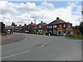
1
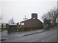
The Church of the Holy Family and Community Centre
Image: © Alexander P Kapp
Taken: 27 Jan 2009
0.04 miles
5
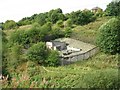
Pumping Station
A pumping Station in Medlock Vale near Woodhouses. SJ899999.
Image: © Keith Williamson
Taken: 21 Sep 2005
0.19 miles
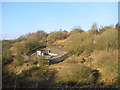
6
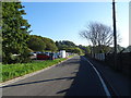
Green Lane
Looking east by the sewage works.
Image: © JThomas
Taken: 10 Oct 2018
0.20 miles
9
Water Treatment Pump House
Jericho Clough, Failsworth.
Image: © John Topping
Taken: 18 Feb 2013
0.21 miles
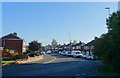
10

United Utilities, Failsworth
Wastewater treatment works, Green Lane, Failsworth.
Image: © John Topping
Taken: 31 Jan 2013
0.22 miles