IMAGES TAKEN NEAR TO
Norfolk Crescent, MANCHESTER, M35 0NS
Introduction
This page details the photographs taken nearby to Norfolk Crescent, M35 0NS by members of the Geograph project.
The Geograph project started in 2005 with the aim of publishing, organising and preserving representative images for every square kilometre of Great Britain, Ireland and the Isle of Man.

There are currently over 7.5m images from over14,400 individuals and you can help contribute to the project by visiting https://www.geograph.org.uk
Image Map
Images are licensed for reuse under creativecommons.org/licenses/by-sa/2.0
Notes
- Clicking on the map will re-center to the selected point.
- The higher the marker number, the further away the image location is from the centre of the postcode.
Image Listing (31 Images Found)
Images are licensed for reuse under creativecommons.org/licenses/by-sa/2.0
Image
Details
Distance
1
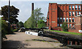
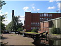
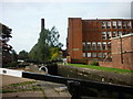
Lock 66, Rochdale Canal
Between Failsworth and Newton Heath.
Image: © michael ely
Taken: 16 May 2014
0.19 miles
2
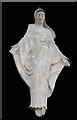
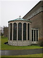
Statue of St Mary at St Mary's Catholic Church, Failsworth
Image: © Alexander P Kapp
Taken: 27 Jan 2009
0.19 miles
3
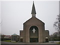
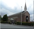
St Mary's Catholic Church, Failsworth
Image: © Alexander P Kapp
Taken: 27 Jan 2009
0.20 miles
4
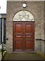
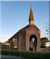
St Mary's Catholic Church, Failsworth, Doorway
Image: © Alexander P Kapp
Taken: 27 Jan 2009
0.20 miles
5
St Mary's Catholic Church, Failsworth
Image: © Alexander P Kapp
Taken: 27 Jan 2009
0.20 miles
6
St Mary's Roman Catholic Church - Failsworth
Image: © Anthony Parkes
Taken: 25 Jun 2014
0.20 miles
10
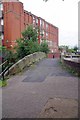
Footbridge by Lock 66
Looking towards Ridgefield St.
Image: © Glyn Baker
Taken: 24 Sep 2016
0.21 miles