IMAGES TAKEN NEAR TO
Ashton Road West, MANCHESTER, M35 0ES

Introduction

This page details the photographs taken nearby to Ashton Road West, M35 0ES by members of the Geograph project.

The Geograph project started in 2005 with the aim of publishing, organising and preserving representative images for every square kilometre of Great Britain, Ireland and the Isle of Man.

There are currently over 7.5m images from over14,400 individuals and you can help contribute to the project by visiting https://www.geograph.org.uk

Image Map


Images are licensed for reuse under creativecommons.org/licenses/by-sa/2.0
Notes
  • Clicking on the map will re-center to the selected point.
  • The higher the marker number, the further away the image location is from the centre of the postcode.

Image Listing (91 Images Found)

Images are licensed for reuse under creativecommons.org/licenses/by-sa/2.0
  • ...
Image
Details
Distance
1
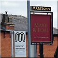
Mare and Foal: signage
Sign for Marston's Mare and Foal Image together with a bus stop sign for the #159 service from Ashton under Lyne to North Manchester General Hospital. In the background is an interesting looking chimney.
Image: © Gerald England Taken: 12 Jun 2021
0.01 miles
2
Mare & Foal, Ashton Road West
Image: © Alexander P Kapp Taken: 27 Jan 2009
0.01 miles
3
Mare and Foal
A Marston's pub on Ashton Road West. It began life in 1833 as the Grey Mare beer house. It was re-built in 1936 and underwent a major refurbishment in 2014. Image
Image: © Gerald England Taken: 12 Jun 2021
0.02 miles
4
Peircy Street, Failsworth
Image: © Alexander P Kapp Taken: 27 Jan 2009
0.02 miles
5
Failsworth Mill
This mill is opposite the better known Regent Mill in Failsworth. Owen Ashmore lists it as Failsworth Mill and it is also in Gurr and Hunt (The Cotton Mills of Oldham). Built 1897 and extended in 1901. Had 15,000 mule spindles in 1915. Chimney has gone but the boiler house (room for two Lancashire boilers), engine house (money on a horizontal cross compound) and rope race survive. The sloping section above the engine house indicates a rope drive and the metal plates in the square section indicate the bearing boxes for the shafts driving the two upper floors. You can divine a lot just by looking. I would welcome any further information. Demolished for housing in 2014
Image: © Chris Allen Taken: 6 Aug 2006
0.04 miles
6
Regent Mill looms above terrace housing at Failsworth
Viewed from Metrolink tram
Image: © Raymond Knapman Taken: 20 Jul 2012
0.06 miles
7
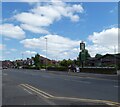
Ashton Road West
Image: © Gerald England Taken: 12 Jun 2021
0.06 miles
8
Rochdale Canal
With Ashton Road West Bridge
Image: © Alexander P Kapp Taken: 27 Jan 2009
0.07 miles
9
Failsworth Mill, Failsworth
Opposite the junction of Ashton Road West and Dunkerley Avenue
Image: © Alexander P Kapp Taken: 27 Jan 2009
0.07 miles
10
Rochdale Canal
From Ashton Road West.
Image: © Gerald England Taken: 12 Jun 2021
0.07 miles
  • ...