IMAGES TAKEN NEAR TO
Hulton Street, MANCHESTER, M35 0AZ
Introduction
This page details the photographs taken nearby to Hulton Street, M35 0AZ by members of the Geograph project.
The Geograph project started in 2005 with the aim of publishing, organising and preserving representative images for every square kilometre of Great Britain, Ireland and the Isle of Man.

There are currently over 7.5m images from over14,400 individuals and you can help contribute to the project by visiting https://www.geograph.org.uk
Image Map
Images are licensed for reuse under creativecommons.org/licenses/by-sa/2.0
Notes
- Clicking on the map will re-center to the selected point.
- The higher the marker number, the further away the image location is from the centre of the postcode.
Image Listing (70 Images Found)
Images are licensed for reuse under creativecommons.org/licenses/by-sa/2.0
Image
Details
Distance

2
Failsworth Telephone Exchange
Located at 179 Oldham Road (A62 road), this TE comprises of the original redbrick building on the left dating from the GPO era with the extension to the right of the photo. It has the code MRFAI and provides telephone and broadband services to 27,455 residential and 920 non-residential premises in Failsworth plus Hollinwood, New Moston, Newton Heath and Woodhouses nearby. Until the late 1960s, it used to have FAIlsworth numbers but now has 0161- 681, 682, and 688 xxxx numbers, the 0161 referring to the Manchester group of TEs. The postcode of this TE is M35 0BX.
Image: © David Hillas
Taken: 24 Jun 2015
0.09 miles
3

Failsworth War Memorial Garden
The wall of the garden behind Image] carries the words:
"THEY DIED IN MANY LANDS SO WE COULD LIVE HERE IN PEACE
IN REMEMBRANCE OF ALL LIVES LOST IN CONFLICT"
The plaque under the tiled Union Flag gives details of the re-dedication of the garden on 10th June 2007 by the Lord Lieutenant of Greater Manchester.
Image: © David Dixon
Taken: 22 Jul 2012
0.15 miles
4

Direction Sign ? Signpost
Located on the northeast side of the junction of the A663 Broadway with the A62 Oldham Road in Oldham metropolitan district. 2 arms and annulus finial.
Milestone Society National ID: LA_SD8801A
Image: © A Norrie
Taken: 15 May 2020
0.15 miles
5
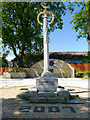
War Memorial and Memorial Garden, Failsworth
The front of the memorial simply carries the dates 1914, 1918. On the back of the memorial, and on the wall of the garden behind, are the words: "THEY DIED IN MANY LANDS SO WE COULD LIVE HERE IN PEACE"
The date "2007" inlaid in the flagging, refers to the date the gardens were re-dedicated.
Image: © David Dixon
Taken: 22 Jul 2012
0.15 miles
6

Someone in Mitchells Quay likes the Rochdale Canal
New housing alongside the Rochdale Canal, west of Back Lane Bridge.
Image: © Christine Johnstone
Taken: 8 May 2014
0.16 miles
7

Where Broadway joins Oldham Road
Two major routes into Manchester converge. You can just see part of Holy Trinity Church behind the trees.
Image: © Bill Boaden
Taken: 2 Jun 2010
0.16 miles
8

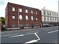
Marlborough No.1 Mill, Failsworth
This is a former cotton spinning mill that was built in 1905 to a design by PS Stott. The spindleage in 1915 was 114,456 and power was provided by a George Saxon inverted vertical triple expansion steam engine of 1700 horsepower. Production ceased in 1955 and it was then used as a distribution warehouse. The adjoining No. 2 Mill has been replaced by a Morrisons supermarket.
Image: © Chris Allen
Taken: 13 Feb 2010
0.16 miles
9
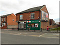
Sub Post Office, Failsworth
Sub Post Office, on Oldham Road (A62), Failsworth. Opposite Broadway, at the corner of Mellor Street.
Image: © David Dixon
Taken: 27 Jan 2011
0.16 miles
10

Dirty lock, Rochdale Canal
This is lock No. 66 and contains a lot of floating junk. Marlborough No. 1 Mill is in the background in the next square west.
Image: © Chris Allen
Taken: 13 Feb 2010
0.16 miles