IMAGES TAKEN NEAR TO
Liverpool Road, MANCHESTER, M3 4NS
Introduction
This page details the photographs taken nearby to Liverpool Road, M3 4NS by members of the Geograph project.
The Geograph project started in 2005 with the aim of publishing, organising and preserving representative images for every square kilometre of Great Britain, Ireland and the Isle of Man.

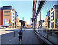
There are currently over 7.5m images from over14,400 individuals and you can help contribute to the project by visiting https://www.geograph.org.uk
Image Map
Images are licensed for reuse under creativecommons.org/licenses/by-sa/2.0
Notes
- Clicking on the map will re-center to the selected point.
- The higher the marker number, the further away the image location is from the centre of the postcode.
Image Listing (1792 Images Found)
Images are licensed for reuse under creativecommons.org/licenses/by-sa/2.0
Image
Details
Distance
1
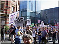
Protest march
Part of the Manchester "Stop the War" march (23 Sept 2006) passes along Deansgate near the newly constructed Beetham Tower (Manchester Hilton Hotel)
Image: © Keith Williamson
Taken: 23 Sep 2006
0.01 miles
2
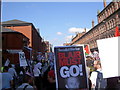
Protest march
Demonstrators on Deansgate, Manchester heading towards Great Northern Square during the 23 Sept. 2006 "Stop the War" protest march
Image: © Keith Williamson
Taken: 23 Sep 2006
0.01 miles
3
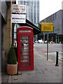
Telephone Box, Liverpool Road, Manchester, Lancashire
Image: © Robert Wade
Taken: 10 Aug 2010
0.01 miles
4
Deansgate, Hilton Hotel
Looking up Great Bridgewater Street, with the Hilton Hotel in the background. http://www.hilton.co.uk/manchesterdeansgate
Image: © Mike Faherty
Taken: 31 Aug 2009
0.01 miles
5
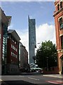
Manchester, Deansgate
The A56, passing through the city centre.
Image: © David Dixon
Taken: 23 Feb 2023
0.02 miles
6
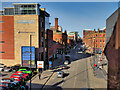
Deansgate
Buildings on the corner of Deansgate and Liverpool Road.
Image: © Peter McDermott
Taken: 20 Aug 2020
0.02 miles
7
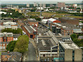
The Museum of Science and Industry
The five Victorian listed buildings on the site of the former Liverpool Road Station which now house the Museum of Science Industry.
In the foreground is the Air and Space Gallery in the old City Exhibition Hall. Across Lower Byrom Street are the shipping (transit) shed (with the large MOSI sign), built in 1855, and next to that, the Great Western Warehouse dating from 1880. Behind, further along Liverpool Road, are the two oldest buildings from the station site; the station building and the warehouse, both dating from the 1830s.
Image: © David Dixon
Taken: 3 Jul 2012
0.02 miles
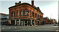
8
Former Free Library, Deansgate, Manchester
Quite a decorative effort of red brick and stone dressings, a succession of arched windows to the first floor, truncated parapets, pediment and moulded chimneystack. Built 1882 to the designs of George Meek. Grade II listed.
At the time of the photo it housed the Institute Cervantes, a Spanish language and cultural centre.
Image: © Stephen Richards
Taken: 24 Jul 2011
0.02 miles
9
Deansgate, Manchester
On a quiet Saturday morning near the City Centre.
Image: © Des Blenkinsopp
Taken: 30 Jun 2018
0.02 miles
10
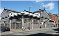
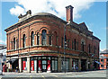
Former Higher Campfield Market, Liverpool Road, Manchester
Recognisably in the same vein as this one Image] just down the road. Built in 1878, also authored by Mangnall & Littlewood, and also of cast iron, wood and glass. There is plenty of pretty ironwork. Grade II listed.
I don't think it was in use at the time of the photo.
Image: © Stephen Richards
Taken: 24 Jul 2011
0.02 miles