IMAGES TAKEN NEAR TO
Barton Street, MANCHESTER, M3 4NN
Introduction
This page details the photographs taken nearby to Barton Street, M3 4NN by members of the Geograph project.
The Geograph project started in 2005 with the aim of publishing, organising and preserving representative images for every square kilometre of Great Britain, Ireland and the Isle of Man.

There are currently over 7.5m images from over14,400 individuals and you can help contribute to the project by visiting https://www.geograph.org.uk
Image Map
Images are licensed for reuse under creativecommons.org/licenses/by-sa/2.0
Notes
- Clicking on the map will re-center to the selected point.
- The higher the marker number, the further away the image location is from the centre of the postcode.
Image Listing (1696 Images Found)
Images are licensed for reuse under creativecommons.org/licenses/by-sa/2.0
Image
Details
Distance
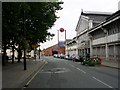
1
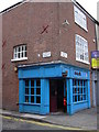
"The Cask" (Pub) 29 Liverpool Road, Manchester M3 4NQ
Image: © Robert Wade
Taken: 10 Aug 2010
0.00 miles
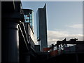
3
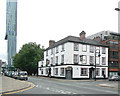
Hotels ancient and modern
The Ox on Liverpool Road of the early 19th century compares with the pencil thin tower which houses the modern Hilton.
Image: © Alan Murray-Rust
Taken: 14 Aug 2009
0.01 miles
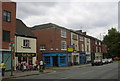
4
Castlefield News
Castlefield News on Liverpool Road.
Image: © Peter McDermott
Taken: 6 Nov 2016
0.02 miles
5
The view from MOSI
Museum of Science & Industry, Manchester, and Beetham Tower
Image: © Peter Barr
Taken: 5 Dec 2009
0.02 miles
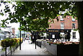
6
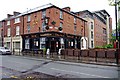
White Lion (1), 43 Liverpool Road, Castlefield, Manchester
Popular with Manchester United Football Club fans on match days. Has large beer garden. It has been a pub since 1813, and is one of the oldest in the city.
Image
Image: © P L Chadwick
Taken: 7 May 2011
0.02 miles
7
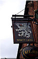
White Lion (2) - sign, 43 Liverpool Road, Castlefield, Manchester
A popular Manchester pub, near the Museum of Science & Industry.
Image
Image: © P L Chadwick
Taken: 7 May 2011
0.02 miles
8
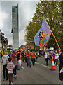
Manchester Day Parade, Liverpool Road
The 2012 Manchester Day Parade passing along Liverpool Road, with the Beetham Tower in the background.
Image: © David Dixon
Taken: 10 Jun 2012
0.02 miles
9
Liverpool Road, Castlefield, Manchester
The building in the right foreground is now the Air and Space Gallery of the Museum of Science and Industry. It began life as Lower Campfield Market (c1878) and is constructed of cast iron columns and wrought iron girders. It was enclosed in the late nineteenth century and became known as City Hall. It was the venue for a regular Christmas circus and was then used for many years as an exhibition hall. After its closure in 1977 it was restored in the early 1980s as the Air and Space Museum.
Image: © Keith Williamson
Taken: 17 Sep 2005
0.02 miles
10
"The White Lion" (Pub) 43 Liverpool Road, Manchester, M3 4NQ
Image: © Robert Wade
Taken: 10 Aug 2010
0.02 miles