IMAGES TAKEN NEAR TO
St. John Street, MANCHESTER, M3 4DF
Introduction
This page details the photographs taken nearby to St. John Street, M3 4DF by members of the Geograph project.
The Geograph project started in 2005 with the aim of publishing, organising and preserving representative images for every square kilometre of Great Britain, Ireland and the Isle of Man.

There are currently over 7.5m images from over14,400 individuals and you can help contribute to the project by visiting https://www.geograph.org.uk
Image Map
Images are licensed for reuse under creativecommons.org/licenses/by-sa/2.0
Notes
- Clicking on the map will re-center to the selected point.
- The higher the marker number, the further away the image location is from the centre of the postcode.
Image Listing (1554 Images Found)
Images are licensed for reuse under creativecommons.org/licenses/by-sa/2.0
Image
Details
Distance
1
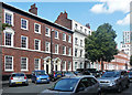
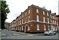
St John Street, Manchester (1)
For all Manchester's embarrassment of Victorian riches, there is startlingly little extant Georgian architecture. I think this is the only complete Georgian street surviving in the city centre. It was built up from the late C18th. The lack of the characteristic Georgian unity is due to building plots being taken up over fifty years or so by different builders. The larger stuccoed house probably dates from the 1840s. Grade II listed.
South side of the street: Image
Image: © Stephen Richards
Taken: 24 Jul 2011
0.01 miles
2
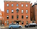
Artillery House
15 Byrom Street is known as Artillery House. A plaque on the wall Image explains that in 1745 the site was used as a gun park by Jacobite Forces under Charles Edward Stuart (Bonny Prince Charlie).
Previously occupied by Hague Lambert Solicitors, the property has recently been transformed into twelve high-spec luxury apartments.
Image: © Gerald England
Taken: 15 Jun 2017
0.01 miles
3
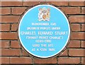
Blue Plaque to Bonny Prince Charlie
A plaque on the wall of 15 Byrom Street Image reads:
IN NOVEMBER 1745
JACOBITE FORCES UNDER
CHARLES EDWARD STUART
('BONNY PRINCE CHARLIE')
(1720-1788)
USED THIS SITE
AS A GUN PARK
Image: © Gerald England
Taken: 15 Jun 2017
0.01 miles
4
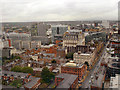
Manchester City Centre
A view from "Cloud 23", the bar on the 23rd floor of the Beetham Tower (Hilton Hotel Image]). This view is looking at the area to the west of Deansgate.
Image: © David Dixon
Taken: 2 Jul 2012
0.02 miles
5
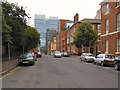
St. John Street
At its junction with Byrom Street.
Image: © philandju
Taken: 3 Aug 2018
0.02 miles
7
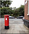
Edward VII Postbox (M3 364D)
St John Street, Manchester.
Image: © Gerald England
Taken: 15 Jun 2017
0.02 miles
8
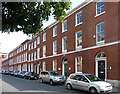
St John Street, Manchester (2)
For all Manchester's embarrassment of Victorian riches, there is startlingly little extant Georgian architecture. I think this is the only complete Georgian street surviving in the city centre. It was built up from the late C18th. The lack of the characteristic Georgian unity is due to building plots being taken up over fifty years or so by different builders. Grade II listed.
North side of the street: Image
Image: © Stephen Richards
Taken: 24 Jul 2011
0.03 miles
9
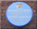
Blue Plaque, Cobden House Chambers, 19 Quay Street, Manchester M3 3HN
Image: © Robert Wade
Taken: 10 Aug 2010
0.03 miles
10
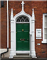
Detail of 25 Byrom Street, Manchester
Example of several pretty Gothick doorcases on the street. They consist of "clustered shafts terminating in pinnacles and ogival heads with finials ... and delicate Gothick tracery in the fanlights". The houses were built c1790. Grade II listed.
Image: © Stephen Richards
Taken: 24 Jun 2011
0.03 miles