IMAGES TAKEN NEAR TO
Potato Wharf, MANCHESTER, M3 4BH
Introduction
This page details the photographs taken nearby to Potato Wharf, M3 4BH by members of the Geograph project.
The Geograph project started in 2005 with the aim of publishing, organising and preserving representative images for every square kilometre of Great Britain, Ireland and the Isle of Man.

There are currently over 7.5m images from over14,400 individuals and you can help contribute to the project by visiting https://www.geograph.org.uk
Image Map
Images are licensed for reuse under creativecommons.org/licenses/by-sa/2.0
Notes
- Clicking on the map will re-center to the selected point.
- The higher the marker number, the further away the image location is from the centre of the postcode.
Image Listing (1061 Images Found)
Images are licensed for reuse under creativecommons.org/licenses/by-sa/2.0
Image
Details
Distance
1
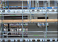
Development on Potato Wharf, Castlefield
New apartments under construction on the Potato Wharf a canal basin.
Image: © michael ely
Taken: 30 Apr 2008
0.02 miles
2

Potato Wharf
Flats on Potato Wharf in the Castlefield area of Manchester.
Image: © Peter McDermott
Taken: 23 Jul 2014
0.02 miles
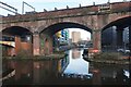
3
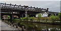
Potato Wharf
Viaducts at Potato Wharf.
Image: © Peter McDermott
Taken: 9 Jul 2016
0.02 miles
4

Potato Wharf, Manchester
Apartment development in the Castlefield area
Image: © Paul Harrop
Taken: 5 Aug 2011
0.03 miles
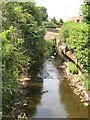
5
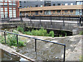
Weir at Potato Wharf
A most interesting design of weir that takes water at the Potato Wharf and links to the nearby River Medlock, which is at a lower level than the canal and actually passes beneath the whole basin complex. Originally water fed into the canal, but its quality deteriorated so drastically that a tunnel was constructed. Under flood conditions the water runs over this circular weir to enter the lower river close to where it surfaces.
Image: © Jonathan Wilkins
Taken: 27 Jun 2010
0.03 miles
8
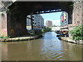
Potato Wharf basin, Castlefield
Seen from a boat on the Bridgewater canal. A second parallel basin, to the west, has been infilled.
Image: © Christine Johnstone
Taken: 22 May 2021
0.03 miles
9
River Medlock
A surprise view of the river which is largely subterranean in this area. Here it emerges from a tunnel beneath the Castlefield canal basin and Potato Wharf, where there is a weir Image The tunnel was constructed to avoid the grossly-polluted water entering the canal except under flood conditions. The water quality has obviously improved dramtically as there is a heron fishing very successfully, and two swans enjoying the cool shade.
Image: © Jonathan Wilkins
Taken: 27 Jun 2010
0.03 miles
10
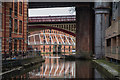
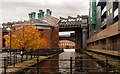
Castlefield
Canals in the Castlefield area of Manchester.
Image: © Peter McDermott
Taken: 23 Jan 2016
0.03 miles