IMAGES TAKEN NEAR TO
Rutland Avenue, MANCHESTER, M34 7UP
Introduction
This page details the photographs taken nearby to Rutland Avenue, M34 7UP by members of the Geograph project.
The Geograph project started in 2005 with the aim of publishing, organising and preserving representative images for every square kilometre of Great Britain, Ireland and the Isle of Man.

There are currently over 7.5m images from over14,400 individuals and you can help contribute to the project by visiting https://www.geograph.org.uk
Image Map
Images are licensed for reuse under creativecommons.org/licenses/by-sa/2.0
Notes
- Clicking on the map will re-center to the selected point.
- The higher the marker number, the further away the image location is from the centre of the postcode.
Image Listing (41 Images Found)
Images are licensed for reuse under creativecommons.org/licenses/by-sa/2.0
Image
Details
Distance
1
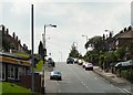
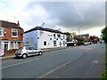
Mill Lane
Passing the end of Manor Road.
Image: © Gerald England
Taken: 27 Jun 2011
0.15 miles
2
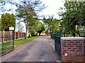
Entrance to former school
Originally Two Trees Secondary School it later became Denton Sports College before merging in 2010 with Egerton Park School. The students were on split sites under the new Denton Community College branding (with Egerton Park being known as 'North Campus' and Two Trees 'South Campus') until the new school building on Taylor Lane opened on 10 January 2012.
Image: © Gerald England
Taken: 11 May 2015
0.19 miles
3
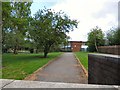
Two Trees School
Originally Two Trees Secondary School it later became Denton Sports College before merging in 2010 with Egerton Park School. The students were on split sites under the new Denton Community College branding (with Egerton Park being known as 'North Campus' and Two Trees 'South Campus') until the new school building on Taylor Lane opened on 10 January 2012.
Image: © Gerald England
Taken: 11 May 2015
0.19 miles
4
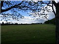
Former school playing fields
Belonging originally to Two Trees Secondary School which later became Denton Sports College before merging in 2010 with Egerton Park School. The students were on split sites under the new Denton Community College branding (with Egerton Park being known as 'North Campus' and Two Trees 'South Campus') until the new school building on Taylor Lane opened on 10 January 2012.
Image: © Gerald England
Taken: 11 May 2015
0.19 miles
5
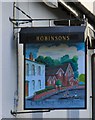
Sign for the Chapel House
Sign of the Chapel House Image
Image: © Gerald England
Taken: 11 May 2015
0.20 miles
6
Chapel House
The Chapel House on Two Trees Lane, Haughton Green.
Image: © David Dixon
Taken: 4 Jun 2011
0.20 miles
7
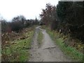
Footpath to Mill Lane
A footpath south of the River Tame between Broomstairs and Mill Lane.
Image: © Gerald England
Taken: 13 Jan 2009
0.20 miles
8
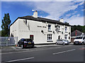
Two Trees Lane
In the foreground is the Robinson's pub "Chapel House".
Image
Image: © Gerald England
Taken: 11 May 2015
0.20 miles
9
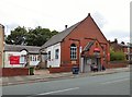
Haughton Green Methodist Church
The church now meets in the former Sunday School and Church Hall after the original chapel was sold in 2011.
Image: © Gerald England
Taken: 6 Jul 2015
0.20 miles
10
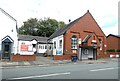
Haughton Green Methodist Centre
The former Sunday School is still used as a place of worship but is no longer a part of the wider Methodist circuit. The hall is used by a variety of community groups.
Image: © Gerald England
Taken: 19 Aug 2023
0.20 miles