IMAGES TAKEN NEAR TO
Rossetti Walk, MANCHESTER, M34 7JZ
Introduction
This page details the photographs taken nearby to Rossetti Walk, M34 7JZ by members of the Geograph project.
The Geograph project started in 2005 with the aim of publishing, organising and preserving representative images for every square kilometre of Great Britain, Ireland and the Isle of Man.

There are currently over 7.5m images from over14,400 individuals and you can help contribute to the project by visiting https://www.geograph.org.uk
Image Map
Images are licensed for reuse under creativecommons.org/licenses/by-sa/2.0
Notes
- Clicking on the map will re-center to the selected point.
- The higher the marker number, the further away the image location is from the centre of the postcode.
Image Listing (47 Images Found)
Images are licensed for reuse under creativecommons.org/licenses/by-sa/2.0
Image
Details
Distance
1
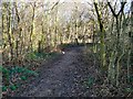
Haughton Green Footpath
A footpath to the West of Haughton Green.
Image: © Gerald England
Taken: 10 Feb 2009
0.06 miles
2
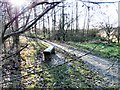
Haughton Green
A bench on a footpath West of Haughton Green.
Image: © Gerald England
Taken: 10 Feb 2009
0.07 miles
3
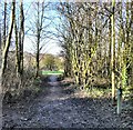
Haughton Green Footpath
A footpath leading towards the River Tame.
Image: © Gerald England
Taken: 10 Feb 2009
0.10 miles
4
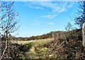
Tameside Field
Fields West of Haughton Green.
Image: © Gerald England
Taken: 10 Feb 2009
0.11 miles
5
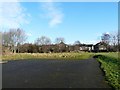
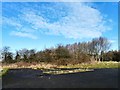
Haughton Green
Recreational land off Chaucer Avenue, Haughton Green.
Image: © Gerald England
Taken: 10 Feb 2009
0.13 miles
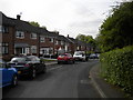
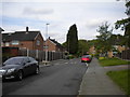
7
Houses on Shepherd Walk, Haughton Green
Off Byron Road.
Image: © Richard Vince
Taken: 12 May 2018
0.15 miles
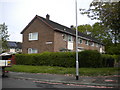
8
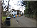
Cottages on Worths Lane
From the side of St Mary's.
Image: © Gerald England
Taken: 16 Mar 2015
0.16 miles
9
Haughton Green
Recreational land at Haughton Green.
Image: © Gerald England
Taken: 10 Feb 2009
0.16 miles