IMAGES TAKEN NEAR TO
Devaney Walk, MANCHESTER, M34 6PZ
Introduction
This page details the photographs taken nearby to Devaney Walk, M34 6PZ by members of the Geograph project.
The Geograph project started in 2005 with the aim of publishing, organising and preserving representative images for every square kilometre of Great Britain, Ireland and the Isle of Man.

There are currently over 7.5m images from over14,400 individuals and you can help contribute to the project by visiting https://www.geograph.org.uk
Image Map
Images are licensed for reuse under creativecommons.org/licenses/by-sa/2.0
Notes
- Clicking on the map will re-center to the selected point.
- The higher the marker number, the further away the image location is from the centre of the postcode.
Image Listing (5 Images Found)
Images are licensed for reuse under creativecommons.org/licenses/by-sa/2.0
Image
Details
Distance
1
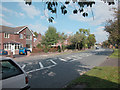
Denton suburb
Main route between Denton and Bredbury. Grid square almost totally residential.
Image: © Dennis Turner
Taken: 10 Oct 2005
0.13 miles
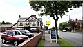
3
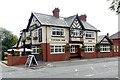
Fletchers Arms
The Fletchers Arms public house on Stockport Road.
Image: © Peter McDermott
Taken: 23 Aug 2014
0.17 miles
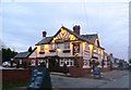
4
Fletchers Arms
Large and popular pub/restaurant in Haughton Green
Image: © Graham Hogg
Taken: 23 Jun 2015
0.18 miles