IMAGES TAKEN NEAR TO
Saxon Lane, MANCHESTER, M34 5ZS
Introduction
This page details the photographs taken nearby to Saxon Lane, M34 5ZS by members of the Geograph project.
The Geograph project started in 2005 with the aim of publishing, organising and preserving representative images for every square kilometre of Great Britain, Ireland and the Isle of Man.

There are currently over 7.5m images from over14,400 individuals and you can help contribute to the project by visiting https://www.geograph.org.uk
Image Map
Images are licensed for reuse under creativecommons.org/licenses/by-sa/2.0
Notes
- Clicking on the map will re-center to the selected point.
- The higher the marker number, the further away the image location is from the centre of the postcode.
Image Listing (169 Images Found)
Images are licensed for reuse under creativecommons.org/licenses/by-sa/2.0
Image
Details
Distance
1
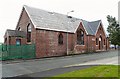
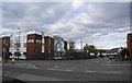
Former Audenshaw United Reformed Church
At the corner of Mount Pleasant Street and Bridge Street. The church is now used as a joinery workshop. The fellowship joined with Guide Lane Methodist Church Image and Red Hall Methodist Church Image to form Trinity Church Image on Audenshaw Road, Audenshaw.
Image: © Gerald England
Taken: 28 Jul 2009
0.04 miles
2
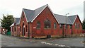
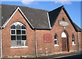
Former Audenshaw United Reformed Church
At the corner of Mount Pleasant Street and Bridge Street. The church is now used as a joinery workshop. The fellowship joined with Guide Lane Methodist Church Image and Red Hall Methodist Church Image to form Trinity Church Image on Audenshaw Road, Audenshaw.
Image: © Gerald England
Taken: 28 Jul 2009
0.04 miles
4
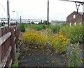
Wildflowers at Guide Bridge
Between the railway lines and the car park, wildflowers, including the noxious ragwort, grow in profusion on an unused portion of the station yard.
Image: © Gerald England
Taken: 28 Jul 2009
0.07 miles
5
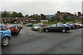
Guide Bridge Station
The car park at Guide Bridge station leads directly to the Manchester-bound platform.
Image: © Gerald England
Taken: 28 Jul 2009
0.07 miles
6
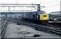
Guide Bridge loco holding sidings
This was a busy location where the electric locos which worked the Woodhead route and the diesels would change traction. There were once extensive sidings and yards at Guide Bridge with plenty of freight traffic.The Woodhead line shut in 1981 and now days very few freight trains head through Guide Bridge.
Image: © roger geach
Taken: 29 Sep 1980
0.07 miles
7
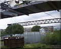
Guide Bridge signal box
View from passing train beneath footbridge
Image: © Raymond Knapman
Taken: 24 Jun 2011
0.08 miles
8
Brother UK
A Japanese sewing-machine manufacturer and a major employer in Audenshaw. For many years they were the shirt sponsor of Manchester City FC.
Image: © Bill Boaden
Taken: 26 Apr 2010
0.08 miles
9
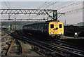
Arrival From Glossop
A Class 506 electric multiple unit arrives at Guide Bridge with a service for Manchester Victoria. Ordered by the LNER in 1938, the units were not actually built until 1950 after the Second World War. Even then, the route was not ready until 1954 when the units finally entered service in June of that year. They remained in service until December 1984 when the route was converted to 25kV AC from the original 1500V DC. They were the last 1500V DC passenger trains in the UK.
Image: © Martin Addison
Taken: Unknown
0.08 miles
10
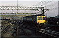
Guide Bridge Eastern Station Approach
A Gloucester Railway Carriage & Wagon built diesel multiple unit arrives from the Glossop direction. The lines on the left lead to Stalybridge.
Image: © Martin Addison
Taken: Unknown
0.08 miles