IMAGES TAKEN NEAR TO
Tame Street, MANCHESTER, M34 5TX
Introduction
This page details the photographs taken nearby to Tame Street, M34 5TX by members of the Geograph project.
The Geograph project started in 2005 with the aim of publishing, organising and preserving representative images for every square kilometre of Great Britain, Ireland and the Isle of Man.

There are currently over 7.5m images from over14,400 individuals and you can help contribute to the project by visiting https://www.geograph.org.uk
Image Map
Images are licensed for reuse under creativecommons.org/licenses/by-sa/2.0
Notes
- Clicking on the map will re-center to the selected point.
- The higher the marker number, the further away the image location is from the centre of the postcode.
Image Listing (145 Images Found)
Images are licensed for reuse under creativecommons.org/licenses/by-sa/2.0
Image
Details
Distance
1
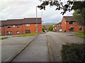
Manor Walk
Houses behind Guide Lane.
Image: © Gerald England
Taken: 15 Sep 2010
0.02 miles
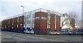
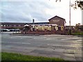
3
Brother UK
A Japanese sewing-machine manufacturer and a major employer in Audenshaw. For many years they were the shirt sponsor of Manchester City FC.
Image: © Bill Boaden
Taken: 26 Apr 2010
0.03 miles
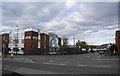
6

Guide Bridge Medical Centre
On Guide Lane at the corner of Water Street.
Image: © Gerald England
Taken: 21 May 2012
0.05 miles
7
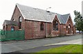
Former Audenshaw United Reformed Church
At the corner of Mount Pleasant Street and Bridge Street. The church is now used as a joinery workshop. The fellowship joined with Guide Lane Methodist Church Image and Red Hall Methodist Church Image to form Trinity Church Image on Audenshaw Road, Audenshaw.
Image: © Gerald England
Taken: 28 Jul 2009
0.06 miles
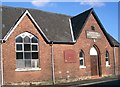
8
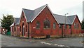
Former Audenshaw United Reformed Church
At the corner of Mount Pleasant Street and Bridge Street. The church is now used as a joinery workshop. The fellowship joined with Guide Lane Methodist Church Image and Red Hall Methodist Church Image to form Trinity Church Image on Audenshaw Road, Audenshaw.
Image: © Gerald England
Taken: 28 Jul 2009
0.06 miles
9
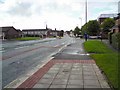
Guide Lane
The A6017 from Stockport to Ashton under Lyne.
Image: © Gerald England
Taken: 15 Sep 2010
0.06 miles
10
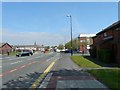
Guide Lane
The A6017 from Stockport to Ashton under Lyne approaching Guide Bridge.
Image: © Gerald England
Taken: 21 May 2012
0.06 miles