IMAGES TAKEN NEAR TO
St. Stephens Avenue, MANCHESTER, M34 5TR
Introduction
This page details the photographs taken nearby to St. Stephens Avenue, M34 5TR by members of the Geograph project.
The Geograph project started in 2005 with the aim of publishing, organising and preserving representative images for every square kilometre of Great Britain, Ireland and the Isle of Man.

There are currently over 7.5m images from over14,400 individuals and you can help contribute to the project by visiting https://www.geograph.org.uk
Image Map
Images are licensed for reuse under creativecommons.org/licenses/by-sa/2.0
Notes
- Clicking on the map will re-center to the selected point.
- The higher the marker number, the further away the image location is from the centre of the postcode.
Image Listing (200 Images Found)
Images are licensed for reuse under creativecommons.org/licenses/by-sa/2.0
Image
Details
Distance
1
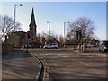
Guide Bridge junction
Busy road junction where the A6017 Ashton to Stockport road meets the B6390 carrying traffic which has just left the M60.
Image: © David Dixon
Taken: 30 Jan 2010
0.03 miles
2
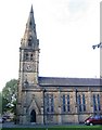
St. Stephen's Church, Audenshaw
This grade II listed building was built in 1846.
Image: © Peter Craine
Taken: 26 Sep 2006
0.04 miles
3
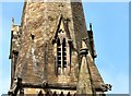
Gargoyles at St Stephen's
Gargoyles at the base of the steeple of St Stephen's Image
Image: © Gerald England
Taken: 21 May 2012
0.04 miles
4
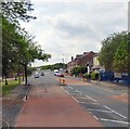
Audenshaw Road
The A6140 is the Ashton under Lyne western bypass http://www.sabre-roads.org.uk/wiki/index.php?title=A6140 which starts at traffic lights at the junction of Stockport Road and Guide Lane Image and heads west along Audenshaw Road. This part of the A6140 was formerly the eastern end of the B6390.
Image: © Gerald England
Taken: 13 Jun 2015
0.04 miles
5
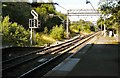
Guide Bridge West Junction
The remaining connection at the west end of the station, leading off to Stockport. Until the early 1980s, this was a four-track railway, with multi-track junctions both left and right, all busy with freight. Now the main line goes through to Manchester Piccadilly. The left fork is still used for freight and once a week only carries a service from Stockport to Stalybridge calling at Reddish South and Denton.
View this junction in 1988: Image
Image: © Gerald England
Taken: 16 Aug 2010
0.04 miles
6
St Stephen, Audenshaw - Church of England
Image: © Gary Barber
Taken: 10 Apr 2005
0.04 miles
7
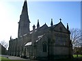
St Stephen's Church, Guide Bridge
The rear elevation of St Stephen's Church, viewed from Guide Lane
Image: © David Dixon
Taken: 30 Jan 2010
0.04 miles
8
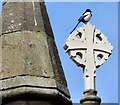
Magpie at St Stephen's
A lone magpie perches on top of a cross at St Stephen's church Image
Image: © Gerald England
Taken: 21 May 2012
0.04 miles
9
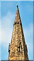
St Stephen's spire
The top of the spire St Stephen's Image
Image: © Gerald England
Taken: 21 May 2012
0.04 miles
10
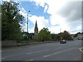
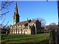
St Stephen's Church, Audenshaw
The Grade II listed https://historicengland.org.uk/listing/the-list/list-entry/1309267?section=official-list-entry church dates from 1845. The chancel was added in 1900. St. Stephen's is part of the Audenshaw and Denton Mission Partnership along with St. Anne's, Haughton, Denton, St. Lawrence's, Denton and Christ Church, Denton with St. George's, Dane Bank.
Viewed from Guide Lane, A6017 which turns right here. The road to the left is now the A6140 (formerly B6390).
Image: © Gerald England
Taken: 1 Oct 2022
0.04 miles