IMAGES TAKEN NEAR TO
Manchester Road, MANCHESTER, M34 5QS
Introduction
This page details the photographs taken nearby to Manchester Road, M34 5QS by members of the Geograph project.
The Geograph project started in 2005 with the aim of publishing, organising and preserving representative images for every square kilometre of Great Britain, Ireland and the Isle of Man.

There are currently over 7.5m images from over14,400 individuals and you can help contribute to the project by visiting https://www.geograph.org.uk
Image Map
Images are licensed for reuse under creativecommons.org/licenses/by-sa/2.0
Notes
- Clicking on the map will re-center to the selected point.
- The higher the marker number, the further away the image location is from the centre of the postcode.
Image Listing (63 Images Found)
Images are licensed for reuse under creativecommons.org/licenses/by-sa/2.0
Image
Details
Distance
2
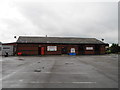
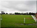
Aldwinians R.U.F.C - Audenshaw
The club house of Aldwinians Rugby Union Football Club.
Image: © John Topping
Taken: 4 Oct 2012
0.13 miles
3
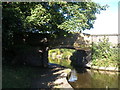
Ashton Canal bridge 20, Ridgewater Bridge
Image: © John Slater
Taken: 22 Sep 2012
0.13 miles
4
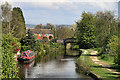
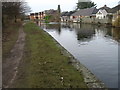
Ashton Canal
Ashton Canal seen from Manchester Road.
Image: © Peter McDermott
Taken: 26 Apr 2014
0.13 miles
6
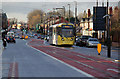
Tram on Droylsden Road
On the approach to Audenshaw tram stop. This is the final section of street running on this route.
Image: © Alan Murray-Rust
Taken: 7 Jan 2014
0.15 miles
10
Droylsden Road
Looking West along the A662 from near Kenilworth Grove.
Image: © Gerald England
Taken: 9 Jun 2011
0.15 miles