IMAGES TAKEN NEAR TO
Leech Brook Close, MANCHESTER, M34 5PL
Introduction
This page details the photographs taken nearby to Leech Brook Close, M34 5PL by members of the Geograph project.
The Geograph project started in 2005 with the aim of publishing, organising and preserving representative images for every square kilometre of Great Britain, Ireland and the Isle of Man.

There are currently over 7.5m images from over14,400 individuals and you can help contribute to the project by visiting https://www.geograph.org.uk
Image Map
Images are licensed for reuse under creativecommons.org/licenses/by-sa/2.0
Notes
- Clicking on the map will re-center to the selected point.
- The higher the marker number, the further away the image location is from the centre of the postcode.
Image Listing (24 Images Found)
Images are licensed for reuse under creativecommons.org/licenses/by-sa/2.0
Image
Details
Distance
1
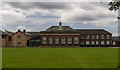
Audenshaw School
View of Audenshaw School.
Image: © Peter McDermott
Taken: 29 Aug 2015
0.09 miles
2
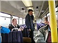
Aboard the Denton Flyer
The ticket inspector is talking to passengers on the once-weekly "Denton Flyer" from Stockport to Stalybridge which is the only train that stops at Reddish South and Denton stations. The train was here halted at Denton junction.
Image: © Gerald England
Taken: 15 Feb 2013
0.14 miles
3
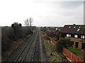
Railway Line, towards Denton Junction
View s/w from Stamford Road bridge, on the Guide Bridge to Stockport line.
Image: © John Topping
Taken: 12 Feb 2013
0.16 miles
4
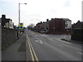
Stamford Road, Audenshaw
Mini-roundabout junction with Corporation Road.
Image: © John Topping
Taken: 12 Feb 2013
0.16 miles
5
We're watching you
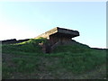
WWII observation point located on the eastern side of Audenshaw reservoir, it has got views both ways along the nearby railway line. It also offers excellent views towards kinder Scout and surrounding areas. There is also a slit built in the rear of it which looks out over the reservoir behind, the rear part of the bunker is actually built into the wall. There is a possibility this slit may have been used for firing practice over the water. Please note: this picture was taken before the reservoirs were fenced off to the general public.
Image: © Paul McCann
Taken: 23 Sep 2006
0.16 miles
6
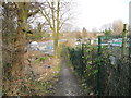
Stamford Road to Guide Bridge footpath
Footpath between the railway (left) and the allotments (right).
Image: © John Topping
Taken: 12 Feb 2013
0.18 miles
7
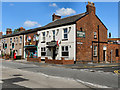
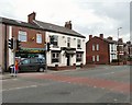
Stamford Arms
The Stamford Arms public house at the corner of Stanhope Street and Denton Road. The shop to the left of the pub used to be a post office.
Image: © David Dixon
Taken: 3 Jun 2011
0.20 miles
8
Stamford Arms
The Stamford Arms public house at the corner of Stanhope Street and Denton Road.
Update (April 2013): the pub has been converted and is now Kim Metcalf Funeral Services and the shop next door, which used to be a post office, is Radhira's off licence (see Gerald England's photo Image]).
Image: © David Dixon
Taken: 3 Jun 2011
0.20 miles
9
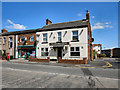
From Pub & Post Office to Funeral Parlour & Off-licence
The former Stamford Arms Image is now Kim Metcalf Funeral Services and the former post office is Radhira's off licence.
Image: © Gerald England
Taken: 2 Apr 2013
0.21 miles
10
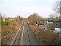
Stockport to Guide Bridge railway line
View n/e from Stamford Road bridge towards Guide Bridge.
Image: © John Topping
Taken: 12 Feb 2013
0.21 miles