IMAGES TAKEN NEAR TO
Sandringham Avenue, MANCHESTER, M34 5PE
Introduction
This page details the photographs taken nearby to Sandringham Avenue, M34 5PE by members of the Geograph project.
The Geograph project started in 2005 with the aim of publishing, organising and preserving representative images for every square kilometre of Great Britain, Ireland and the Isle of Man.

There are currently over 7.5m images from over14,400 individuals and you can help contribute to the project by visiting https://www.geograph.org.uk
Image Map
Images are licensed for reuse under creativecommons.org/licenses/by-sa/2.0
Notes
- Clicking on the map will re-center to the selected point.
- The higher the marker number, the further away the image location is from the centre of the postcode.
Image Listing (12 Images Found)
Images are licensed for reuse under creativecommons.org/licenses/by-sa/2.0
Image
Details
Distance
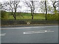
1
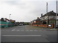
Sandringham Avenue, Audenshaw
Viewed across Stamford Road. In the background is the eastern banking of Audenshaw Reservoir No 1.
Image: © John Topping
Taken: 12 Feb 2013
0.02 miles
3
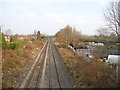
Stockport to Guide Bridge railway line
View n/e from Stamford Road bridge towards Guide Bridge.
Image: © John Topping
Taken: 12 Feb 2013
0.08 miles
4
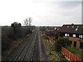
Railway Line, towards Denton Junction
View s/w from Stamford Road bridge, on the Guide Bridge to Stockport line.
Image: © John Topping
Taken: 12 Feb 2013
0.09 miles
5
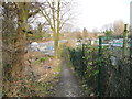
Stamford Road to Guide Bridge footpath
Footpath between the railway (left) and the allotments (right).
Image: © John Topping
Taken: 12 Feb 2013
0.10 miles
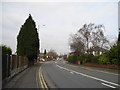
6
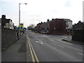
Stamford Road, Audenshaw
Mini-roundabout junction with Corporation Road.
Image: © John Topping
Taken: 12 Feb 2013
0.13 miles
7
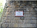
DJ01/2 Bridge notice - Network Rail
Railway bridge over the B6390 Audenshaw Road.
Image: © John Topping
Taken: 17 Oct 2012
0.16 miles
8
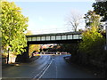
Railway Bridge DJ01/2, Audenshaw
Carrying the Denton Junction (SJ9196) to Ashton Moss North Junction (SJ9299) railway line over the B6390 Audenshaw Road.
Image: © John Topping
Taken: 17 Oct 2012
0.16 miles
9
Audenshaw Reservoir #1 embankment
The bank of Audenshaw reservoir #1. On the wall is a commemorative stone Image recording the rebuilding by Manchester Waterworks of Red Hall Chapel (now Trinity Church Image) following the drowning of the original chapel in the reservoir.
Image: © Gerald England
Taken: 30 Oct 2012
0.20 miles
10
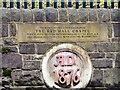
Red Hall Chapel 1876 datestone
1876 datestone and inscription on the wall opposite Red Hall Chapel Image which was rebuilt by Manchester Waterworks when the original chapel was drowned by Audenshaw Reservoir #1. The chapel, now part of the Trinity Church Image, was rebuilt again in 2008.
Image: © Gerald England
Taken: 30 Oct 2012
0.21 miles