IMAGES TAKEN NEAR TO
Aldwyn Park Road, MANCHESTER, M34 5NZ
Introduction
This page details the photographs taken nearby to Aldwyn Park Road, M34 5NZ by members of the Geograph project.
The Geograph project started in 2005 with the aim of publishing, organising and preserving representative images for every square kilometre of Great Britain, Ireland and the Isle of Man.

There are currently over 7.5m images from over14,400 individuals and you can help contribute to the project by visiting https://www.geograph.org.uk
Image Map
Images are licensed for reuse under creativecommons.org/licenses/by-sa/2.0
Notes
- Clicking on the map will re-center to the selected point.
- The higher the marker number, the further away the image location is from the centre of the postcode.
Image Listing (58 Images Found)
Images are licensed for reuse under creativecommons.org/licenses/by-sa/2.0
Image
Details
Distance
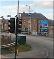
1
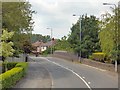
Audenshaw Road
The B6390 crossing the railway line.
Image: © Gerald England
Taken: 13 Jun 2015
0.06 miles
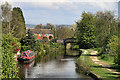
2
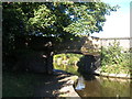
Ashton Canal bridge 20, Ridgewater Bridge
Image: © John Slater
Taken: 22 Sep 2012
0.08 miles
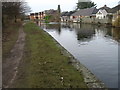
5
Ashton Canal
Ashton Canal seen from Manchester Road.
Image: © Peter McDermott
Taken: 26 Apr 2014
0.11 miles
6
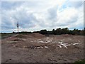
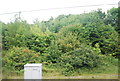
Reclaimed Land
Former industrial land off Audenshaw Road and Kings Road "reclaimed for future use". The probability is that it will be used for housing.
Image: © Gerald England
Taken: 6 May 2009
0.13 miles
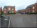
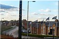
8
The Grange
New housing on Kings Road, Audenshaw.
Image: © Gerald England
Taken: 28 Nov 2012
0.14 miles
9
The Grange
New housing on Kings Road, Audenshaw.
Image: © Gerald England
Taken: 28 Nov 2012
0.15 miles
10
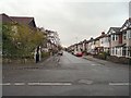
Aldwyn Park Road
Residential street off Lumb Lane.
Image: © Gerald England
Taken: 30 Oct 2012
0.15 miles