IMAGES TAKEN NEAR TO
Slate Lane, MANCHESTER, M34 5GW
Introduction
This page details the photographs taken nearby to Slate Lane, M34 5GW by members of the Geograph project.
The Geograph project started in 2005 with the aim of publishing, organising and preserving representative images for every square kilometre of Great Britain, Ireland and the Isle of Man.

There are currently over 7.5m images from over14,400 individuals and you can help contribute to the project by visiting https://www.geograph.org.uk
Image Map
Images are licensed for reuse under creativecommons.org/licenses/by-sa/2.0
Notes
- Clicking on the map will re-center to the selected point.
- The higher the marker number, the further away the image location is from the centre of the postcode.
Image Listing (79 Images Found)
Images are licensed for reuse under creativecommons.org/licenses/by-sa/2.0
Image
Details
Distance
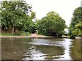
2
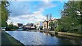
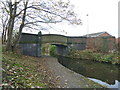
Ashton Canal from Lumb Lane Bridge
Image: © Alexander P Kapp
Taken: 21 Nov 2011
0.06 miles
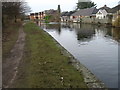
3
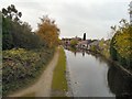
Ashton Canal
Looking west from Lumb Lane bridge towards the houses on Slate Lane.
Image: © Gerald England
Taken: 30 Oct 2012
0.08 miles
4
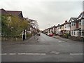
Aldwyn Park Road
Residential street off Lumb Lane.
Image: © Gerald England
Taken: 30 Oct 2012
0.10 miles
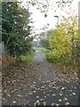
5
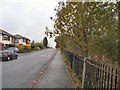
Lumb Lane
Before being cut off by the M60 motorway, Lumb Lane was a busy link between Denton and Droylsden.
Image: © Gerald England
Taken: 30 Oct 2012
0.10 miles
7
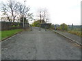
Miss information
The sat nav said Lumb Lane was a through road but the posts say NO
Image: © Alexander P Kapp
Taken: 21 Nov 2011
0.11 miles
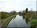
8
Ashton Canal near Lumb Lane
On the right is Lumb Lane bridge which is the lowest on the canal.
Image: © Gerald England
Taken: 12 Jun 2018
0.11 miles