IMAGES TAKEN NEAR TO
Church Close, MANCHESTER, M34 5FH
Introduction
This page details the photographs taken nearby to Church Close, M34 5FH by members of the Geograph project.
The Geograph project started in 2005 with the aim of publishing, organising and preserving representative images for every square kilometre of Great Britain, Ireland and the Isle of Man.

There are currently over 7.5m images from over14,400 individuals and you can help contribute to the project by visiting https://www.geograph.org.uk
Image Map
Images are licensed for reuse under creativecommons.org/licenses/by-sa/2.0
Notes
- Clicking on the map will re-center to the selected point.
- The higher the marker number, the further away the image location is from the centre of the postcode.
Image Listing (171 Images Found)
Images are licensed for reuse under creativecommons.org/licenses/by-sa/2.0
Image
Details
Distance
1
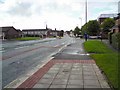
Guide Lane
The A6017 from Stockport to Ashton under Lyne.
Image: © Gerald England
Taken: 15 Sep 2010
0.03 miles
2
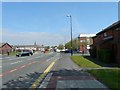
Guide Lane
The A6017 from Stockport to Ashton under Lyne approaching Guide Bridge.
Image: © Gerald England
Taken: 21 May 2012
0.03 miles
4

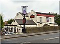
Sign for the Junction Inn
The sign of the Junction Inn Image on Guide Lane depicts a steam train passing Guide Bridge station.
Image: © Gerald England
Taken: 28 Jul 2009
0.05 miles
5
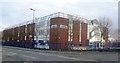
Brother UK
A Japanese sewing-machine manufacturer and a major employer in Audenshaw. For many years they were the shirt sponsor of Manchester City FC.
Image: © Bill Boaden
Taken: 26 Apr 2010
0.05 miles
7

Sign for the Junction Inn
Although for now the roadside sign still hangs, the pub has been demolished Image
Image: © Gerald England
Taken: 21 May 2012
0.06 miles
8
Loxley Homes
Image: © Gerald England
Taken: 15 Feb 2013
0.07 miles
9
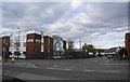
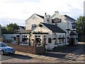
Junction Inn
On Guide Lane near to Guide Bridge station.
Image
Update (2012): The public house has since been demolished Image
Image: © Gerald England
Taken: 28 Jul 2009
0.07 miles
10
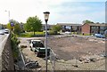
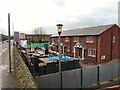
Site of the Junction Inn
Site of the recently demolished Junction Inn on Scott Gate off Guide Lane. As yet the roadside sign is still standing Image
2006: Image
2009: Image
Image: © Gerald England
Taken: 21 May 2012
0.07 miles