IMAGES TAKEN NEAR TO
Birch Grove, MANCHESTER, M34 5DN
Introduction
This page details the photographs taken nearby to Birch Grove, M34 5DN by members of the Geograph project.
The Geograph project started in 2005 with the aim of publishing, organising and preserving representative images for every square kilometre of Great Britain, Ireland and the Isle of Man.

There are currently over 7.5m images from over14,400 individuals and you can help contribute to the project by visiting https://www.geograph.org.uk
Image Map
Images are licensed for reuse under creativecommons.org/licenses/by-sa/2.0
Notes
- Clicking on the map will re-center to the selected point.
- The higher the marker number, the further away the image location is from the centre of the postcode.
Image Listing (34 Images Found)
Images are licensed for reuse under creativecommons.org/licenses/by-sa/2.0
Image
Details
Distance
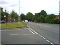
1
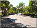
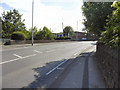
Shepley Road
Shepley Road (B6169) climbing towards Audenshaw, from Shepley Bridge.
Image: © David Dixon
Taken: 4 Jun 2011
0.04 miles
2
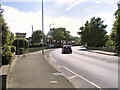
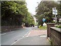
Entering Audenshaw
Shepley Road (B6169) crossing the River Tame at Shepley Bridge, which forms the boundary between the old urban districts of Dukinfield and Audenshaw.
Image: © David Dixon
Taken: 4 Jun 2011
0.07 miles
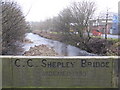
4
Shepley Bridge - B6169 Crosses the River Tame
Image: © Anthony Parkes
Taken: 2 Mar 2012
0.07 miles
5
Shepley Bridge
Shepley Road (B6169) crossing the River Tame.
Image: © David Dixon
Taken: 4 Jun 2011
0.07 miles
6
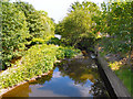
River Tame, Shepley
Looking downstream from Shepley Bridge.
Image: © David Dixon
Taken: 4 Jun 2011
0.11 miles
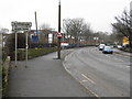
8
Hooley Hill
The junction of Shepley Road and Cemetery Road, Audenshaw.
Image: © Gerald England
Taken: 1 Aug 2011
0.15 miles
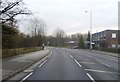
9
Shepley Road
Looking east along Shepley Road in the Hooley Hill area of Audenshaw. The road drops down from here into the valley of the River Tame.
Image: © Keith Williamson
Taken: 23 Jun 2007
0.16 miles
10
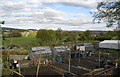
Allotments and the Tame valley
Beyond the allotments are King George's Playing Fields. The River Tame and Dukinfield are further on.
Image: © Bill Boaden
Taken: 26 Apr 2010
0.18 miles